جبال الألپ الأسترالية
|
Australian Alps أستراليا | |||||||||||||||
|---|---|---|---|---|---|---|---|---|---|---|---|---|---|---|---|
|
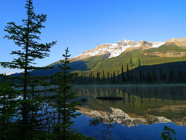
Mount Feathertop, Victoria
| |||||||||||||||
|
The interim Australian bioregions,
with the Australian Alps in red | |||||||||||||||
| Area | 12٬330 km2 (4٬760٫6 sq mi) | ||||||||||||||
| |||||||||||||||
الألپ الأسترالية Australian Alps، هي interim Australian bioregion, هي أعلى سلسلة جبال في أستراليا. This range is located in southeastern Australia, and it straddles eastern Victoria, southeastern New South Wales, and the Australian Capital Territory. The Australian Alps contain Australia's only peaks exceeding 2,000 مترs (6,600 قدم) in elevation above sea level. The Alps are the only bioregion on the Australian mainland in which deep snow falls annually. The Alps comprise an area of 1,232,981 هكتارs (3,046,760 أكرs).
The Australian Alps are part of the Great Dividing Range, the series of mountains, hills, and highlands that runs about 3,000 kiloمترs (9,800,000 قدم) from northern Queensland, through New South Wales, and into the northern part of Victoria. This chain of highlands divides the drainage of the rivers that flow to the east into the Tasman Sea from those that flow west into the drainage of the Murray–Darling basin (and thence to the Southern Ocean) or into inland waters, such as Lake Eyre, which lie below sea level, or else evaporate rapidly. The Great Dividing Range reaches its greatest heights in the Australian Alps.
The Australian Alps consist of two biogeographic subregions: the Snowy Mountains including the Brindabella Range, located in New South Wales and the Australian Capital Territory; and the Victorian Alps, located in Victoria. The latter region is also known as the "High Country", particularly within a cultural or historical context.
معرض صور
The Australian Alps viewed from Snowy River Road, near Suggan Buggan, State of Victoria.
Mount Ginini in the Australian Capital Territory.
Sunset over the Alps from Mount Hotham, Victoria.
Talbingo Dam, a part of the Snowy Mountains Scheme.
Yarrangobilly Caves, located off the Snowy Mountains Highway.
The restored former courthouse and ski chalet of Kiandra, where skiing in Australia began.
The Kosciuszko Main Range seen from Charlotte Pass ski resort.
Mount Feathertop seen from Mount Hotham.
Perisher, New South Wales, is Australia's largest ski resort.
Sunset over Kiandra
پانوراما
الهامش
- ^ Environment Australia. "Revision of the Interim Biogeographic Regionalisation for Australia (IBRA) and Development of Version 5.1 - Summary Report". Department of the Environment and Water Resources, Australian Government. Retrieved on 2007-01-31.
- ^ IBRA Version 6.1 data
- ^ "Interim Biogeographic Regionalisation for Australia (IBRA7) regions and codes". Department of Sustainability, Environment, Water, Population and Communities. Commonwealth of Australia. 2012. Retrieved 13 January 2013.
-
^ "Geology of the Australian alps" (PDF). p. 1. Retrieved 30 November 2013.
The Australian Alps are the highest part of a larger entity, the Eastern Highlands of Australia...
وصلات خارجية
- Australian Alps National Parks official website
نطقب:New South Wales mountains نطقب:Victorian mountains نطقب:Interim Biogeographic Regionalisation for Australia (IBRA)