كانتربري، نيوزيلندا
|
كانتربري
Waitaha
| |
|---|---|
منطقة في نيوزيلندا | |
| منطقة كانتربري | |
|
منطقة كانتربري ضمن نيوزيلندا
| |
| الإحداثيات: Coordinates: | |
| البلد | نيوزيلندا |
| الجزيرة | الجزيرة الجنوبية |
| تأسست | 1989 |
| المقر | كرايست تشرش |
| السلطات الإقليمية | قائمة
|
| الحكم | |
| • Chairperson | Steve Lowndes - Acting Chair |
| المساحة | |
| • Region | 44٬508 كم² (17٬185 ميل²) |
| التعداد(تقدير يونيو2011) | |
| • Region | 560٬700 |
| • الكثافة | 13/km2 (33/sq mi) |
| صفة المواطن | Cantabrian |
| منطقة التوقيت | NZST (التوقيت العالمي المنسق+12) |
| • الصيفي | NZDT (UTC+13) |
| HDI (2017) | 0.925 very high · 4th |
كانتربري (Canterbury ؛ ماوري: Waitaha) هي منطقة في نيوزيلندا، تقع في وسط-شرق الجزيرة الجنوبية. المنطقة تغطي مساحة 44,508 كم²، ويقطنها 560,700 (تقدير يونيو2011) نسمة.
The region in its current form was established in 1989 during nationwide local government reforms. The Kaikoura District joined the region in 1992 following the abolition of the Nelson-Marlborough Regional Council.
Christchurch, the South Island's largest city and the country's third-largest urban area, is the seat of the region and home to 68 percent of the region's population. Other major towns and cities include Timaru, Ashburton, Rangiora and Rolleston.
الديمغرافيا
المناطق الحضرية
| المساحة الحضرية | التعداد (June 2018) |
% of region |
|---|---|---|
| كرايست تشرش | 377,200 | 60٫4% |
| تيمارو | 28,300 | 4٫5% |
| Ashburton | 19,600 | 3٫1% |
| Rangiora | 18,400 | 2٫9% |
| Rolleston | 16,350 | 2٫6% |
| Kaiapoi | 11,850 | 1٫9% |
| Lincoln | 6,030 | 1�0% |
| Temuka | 4,580 | 0٫7% |
| Prebbleton | 4,350 | 0٫7% |
| Waimate | 3,420 | 0٫5% |
| Woodend | 3,100 | 0٫5% |
| Lyttelton | 3,040 | 0٫5% |
| Darfield | 2,900 | 0٫5% |
| Geraldine | 2,630 | 0٫4% |
| Kaikoura | 2,210 | 0٫4% |
| Oxford | 2,200 | 0٫4% |
| Pegasus | 2,080 | 0٫3% |
| Leeston | 2,070 | 0٫3% |
| West Melton | 2,060 | 0٫3% |
| Methven | 1,890 | 0٫3% |
| Amberley | 1,800 | 0٫3% |
| Pleasant Point | 1,430 | 0٫2% |
| Rakaia | 1,420 | 0٫2% |
| Diamond Harbour | 1,380 | 0٫2% |
| Twizel | 1,300 | 0٫2% |
الثقافة والهوية
| أكبر مجموعات من المقيمين المولودين وراء البحار | |
| القومية | التعداد (2013) |
|---|---|
|
|
34,719 |
|
|
8,520 |
|
|
7,380 |
|
|
4,647 |
|
|
4,107 |
|
|
3,087 |
|
|
2,937 |
|
|
2,904 |
|
|
2,754 |
|
|
2,523 |
الاقتصاد
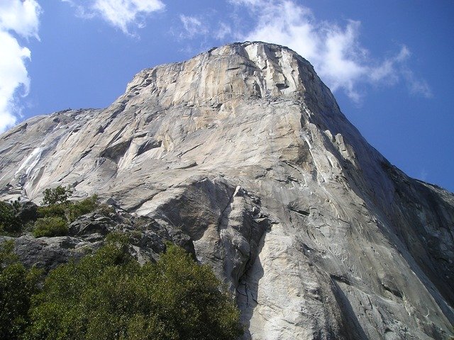
البيئة
مسقط تصوير أفلام
Canterbury was the location used in the filming The Lord of the Rings for the fictional city of Edoras, Rohan, on Mount Sunday, as well as Helm's deep backdrop, several miles down the valley.
انظر أيضاً
- زلزال كانتربري 2010
- February 2011 Christchurch earthquake
- June 2011 Christchurch earthquake
- November 2016 Kaikoura earthquake
- Water pollution in Canterbury, New Zealand
المراجع
- ^ "Subnational population estimates at 30 June 2011 (boundaries at 1 July 2011)". Statistics New Zealand. 19 December 2011. Retrieved 19 December 2011.
- ^ "Sub-national HDI - Area Database - Global Data Lab". hdi.globaldatalab.org (in الإنجليزية). Retrieved 2018-09-13.
- ^ "Subnational Population Estimates: At 30 June 2018 (final)". Statistics New Zealand. 15 November 2018. Retrieved 21 November 2018.
- ^ "Birthplace (detailed), for the census usually resident population count, 2001, 2006, and 2013 (RC, TA) – NZ.Stat". Statistics New Zealand. Retrieved 23 January 2016.
- ^ (DOC), corporatename = New Zealand Department of Conservation. "Lord of the Rings locations". www.doc.govt.nz.
وصلات خارجية
| Wikivoyage has a travel guide for Canterbury (New Zealand). |
- Environment Canterbury (Canterbury Regional Council)
- Canterbury Biodiversity, Environment Canterbury
نطقب:Regions of New Zealand