مقاطعة مسكاتين، آيوا
Muscatine County | |
|---|---|
U.S. county | |
|
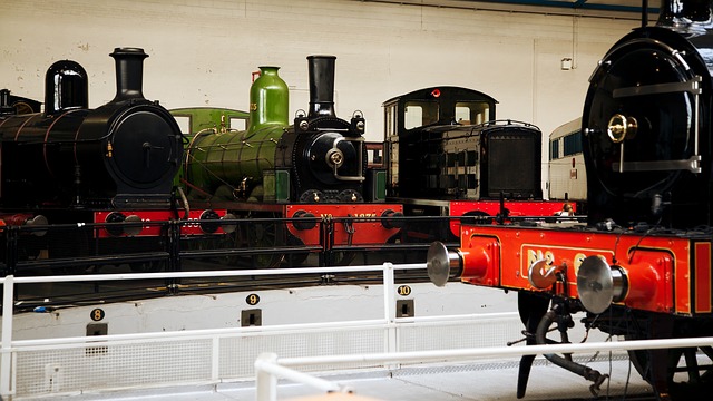
Muscatine County Courthouse in Muscatine
| |
|
Location within the U.S. state of Iowa
| |
|
Map of the United States highlighting Iowa مسقط Iowa ضمن الولايات المتحدة | |
| الإحداثيات: خطأ لوا في وحدة:Coordinates على السطر 611: attempt to index field 'wikibase' (a nil value). | |
| البلد | |
| State |
|
| تأسست | December 7, 1836 |
| Seat | Muscatine |
| Largest city | Muscatine |
| المساحة | |
| • الإجمالية | 449 ميل² (1٬160 كم²) |
| • البر | 437 ميل² (1٬130 كم²) |
| • الماء | 12 ميل² (30 كم²) 2.6%% |
| التعداد(2010) | |
| • الإجمالي | 42٬745 |
| • الكثافة | 98/sq mi (38/km2) |
| منطقة التوقيت | Central (التوقيت العالمي المنسق−6) |
| • الصيفي | CDT (UTC−5) |
| Congressional district | 2nd |
| المسقط الإلكتروني | co.muscatine.ia.us |
مقاطعة مسكاتين بالإنگليزية: Muscatine County هي إحدى مقاطعات ولاية آيوا في الولايات المتحدة الأمريكية.
Adjacent counties
- Cedar County (north)
- Scott County (northeast)
- Rock Island County, Illinois (east), across the Mississippi River
- Louisa County (south)
- Johnson County (northwest)
Transportation
Major highways
- U.S. Highway 6
- U.S. Highway 61
- Iowa Highway 22
- Iowa Highway 38
- Iowa Highway 70
- Iowa Highway 92
Other roadways
- Great River Road
County highways
- County Highway F58 (formerly Hwy 927)
- County Highway F62
- County Highway F65
- County Highway F70 (155th St)
- County Highway G14 (180th St)
- County Highway G28 (230th/231st Sts)
- County Highway G34 (275th St)
- County Highway G38 (Fruitland Rd)
- County Highway X34 (Davis Ave)
- County Highway X40 (Garfield Ave)
- County Highway X46 (Kelly Ave/170th St)
- County Highway X61 (Stewart Rd)
- County Highway Y14 (Taylor Ave)
- County Highway Y26 (Vail Ave)
- County Highway Y30 (Western Ave)
- County Highway Y36 (Zachary Ave)
Demographics
| التعداد التاريخي | |||
|---|---|---|---|
| التعداد | Pop. | %± | |
| 1850 | 5٬731 | — | |
| 1860 | 16٬444 | 186٫9% | |
| 1870 | 21٬688 | 31٫9% | |
| 1880 | 23٬170 | 6٫8% | |
| 1890 | 24٬504 | 5٫8% | |
| 1900 | 28٬242 | 15٫3% | |
| 1910 | 29٬505 | 4٫5% | |
| 1920 | 29٬042 | −1٫6% | |
| 1930 | 29٬385 | 1٫2% | |
| 1940 | 31٬296 | 6٫5% | |
| 1950 | 32٬148 | 2٫7% | |
| 1960 | 33٬840 | 5٫3% | |
| 1970 | 37٬181 | 9٫9% | |
| 1980 | 40٬436 | 8٫8% | |
| 1990 | 39٬907 | −1٫3% | |
| 2000 | 41٬722 | 4٫5% | |
| 2010 | 42٬745 | 2٫5% | |
| تقدير 2014 | 42٬903 | 0٫4% | |
| U.S. Decennial Census 1790-1960 1900-1990 1990-2000 2010-2013 | |||
Communities
C.S. Barclay farm illustration in 1875
Cities
- Atalissa
- Blue Grass (part)
- Durant (part)
- Conesville
- Fruitland
- Muscatine
- Nichols
- Stockton
- Walcott (part)
- West Liberty
- Wilton
Unincorporated communities
- Cranston
- Fairport
- Midway Beach
- Montpelier
- Moscow
- Petersburg
Townships
- Bloomington
- Cedar
- Fruitland
- Fulton
- Goshen
- Lake
- Montpelier
- Moscow
- Orono
- Pike
- Seventy-Six
- Sweetland
- Wapsinonoc
- Wilton
See also
- National Register of Historic Places listings in Muscatine County, Iowa
Notes
- ^ "Annual Estimates of the Resident Population for Incorporated Places: April 1, 2010 to July 1, 2014". Retrieved June 4, 2015.
- ^ "U.S. Decennial Census". United States Census Bureau. Retrieved July 20, 2014.
- ^ "Historical Census Browser". University of Virginia Library. Retrieved July 20, 2014.
- ^ "Population of Counties by Decennial Census: 1900 to 1990". United States Census Bureau. Retrieved July 20, 2014.
- ^ "Census 2000 PHC-T-4. Ranking Tables for Counties: 1990 and 2000" (PDF). United States Census Bureau. Retrieved July 20, 2014.
-
^ خطأ استشهاد: وسم
<ref>غير سليم؛ لا نص تم توفيره للمراجع المسماةQF
وصلات خارجية
| مشاع الفهم فيه ميديا متعلقة بموضوع مقاطعة مسكاتين، آيوا. |
- Muscatine County government's website
نطقب:Muscatine County, Iowa نطقب:Quad Cities نطقب:Iowa
Coordinates: