عرتة
|
عرتة
Carta (صومالية)
عرتة (بالعربية) Arta
| |
|---|---|
بلدة | |
|
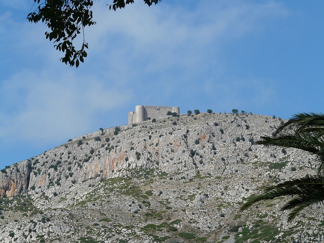
منظر خليج تاجورة من عرتة.
| |
|
عرتة | |
| الإحداثيات: | |
| البلد | جيبوتي |
| المنطقة | عرتة |
| تأسست | القرن 17 |
| المساحة | |
| • الإجمالية | 2 كم² (0٫8 ميل²) |
| الارتفاع | 755 m (2٬477 ft) |
| التعداد | |
| • الإجمالي | 11٬043 |
| منطقة التوقيت | EAT (التوقيت العالمي المنسق+3) |
| المناخ | BSh |
عرتة (بالإنگليزية: Arta، بالصومالية: Carta) هي بلدة في جنوب شرق جيبوتي. وهي مركز منطقة عرتة، وهي سادس أكبر مدينة في البلد. اعتبارا من 2010[تحديث]، فإن عدد سكانها كان 11,043 نسمة. وتقع عرتة في جبال عرتة وتشتهر بمناخها المعتدل. وتقع على بعد نحو41 كم غرب العاصمة مدينة جيبوتي.
التاريخ
The Arta settlement is several centuries old. During the Middle Ages, it was ruled by the Ifat and Adal sultanates. Arta later formed a part of the French Somaliland protectorate in the first half of the 20th century. In the December 1942 British invasion of French Somaliland, about 700 British troops and Free French troops occupied the town. Under French colonial rule in 1946, a new housing estate and hill station was built. Arta's climate lent itself to becoming the prime sanctuary of the French civil servants in Djibouti. In 1963, representatives of the two ethnic groups of Djibouti, the Afar and the Issa, formulated the "Declaration of Arta", in which they professed cohesion under the protection of France. They argued against the influence of the large independent neighboring countries of Ethiopia and Somalia and against the connection to one of these countries.
From May 2, 2000, peace talks between various factions of the Somali Civil War were held in the city with some 810 delegates, resulting in the establishment of the Transitional National Government of Somalia.
الجغرافيا والمناخ
It lies at an elevation of 755 metres (2,477 feet) above sea level. It lies on highlands known as the جبال عرتة. The temperate central portion, where Arta lies, is situated on a rocky highland plateau, which over looks the coastal plains. The town is connected to other environs by National Highway 4. Public buses go from Djibouti City to Arta. It takes half an hour to get to Arta. A contracted bus ride from Djibouti city to Arta can charge between 350 Djiboutian franc. We`a is situated just down the mountain, around ثلاثة kiloمترs (1.9 ميلs) to the south.
Sunshine is abundant in the town, averaging eight to ten hours a day year-round. It is lowest during the wet season, when there is some coastal fog and greater cloud coverage as warm air passes over the mountains.
Arta has a Semi-arid climate (BSh) by the Köppen-Geiger system.
| بيانات مناخ عرتة | |||||||||||||
|---|---|---|---|---|---|---|---|---|---|---|---|---|---|
| الشهر | يناير | فبراير | مارس | أبريل | مايو | يونيو | يوليو | أغسطس | سبتمبر | اكتوبر | نوفمبر | ديسمبر | العام |
| العظمى المتوسطة °س (°ف) | 25.94 (78.7) |
26.22 (79.2) |
26.89 (80.4) |
28.11 (82.6) |
29.33 (84.8) |
33.44 (92.2) |
36.17 (97.1) |
35.67 (96.2) |
31.67 (89.0) |
27.56 (81.6) |
26.67 (80.0) |
26.33 (79.4) |
29٫5 (85٫1) |
| الصغرى المتوسطة °س (°ف) | 15.11 (59.2) |
16.94 (62.5) |
18.22 (64.8) |
19.83 (67.7) |
21.44 (70.6) |
23.72 (74.7) |
25.56 (78.0) |
25.06 (77.1) |
23.33 (74.0) |
20.06 (68.1) |
17.56 (63.6) |
15.33 (59.6) |
20٫181 (68٫33) |
| سقوط الأمطار mm (inches) | 30 (1.18) |
27 (1.06) |
26 (1.02) |
30 (1.18) |
16 (0.63) |
1 (0.04) |
9 (0.35) |
20 (0.79) |
10 (0.39) |
12 (0.47) |
43 (1.69) |
12 (0.47) |
236 (9٫29) |
| Source #1: Climate-Data.org, altitude: 755m | |||||||||||||
| Source #2: Levoyageur | |||||||||||||
الديمغرافيا
اعتبارا من 2013[تحديث], the population of Arta has been estimated to be 11,043. The town inhabitants belong to various mainly Afro-Asiatic-speaking ethnic groups, with the Issa Somali predominant.
البلدات التوأم – المدن الشقيقة
Arta is twinned with:
| البلد | البلدة |
|---|---|
| مالطا | Mġarr |
| اليونان | كندانوس |
| إثيوپيا | هرر |
المراجع
| مشاع الفهم فيه ميديا متعلقة بموضوع Arta, Djibouti. |
- ^ Thompson, Virginia; Adloff, Richard (1968). . Stanford University Press. p. 46. ISBN .
- ^ Seddon, David (15 April 2013). . Routledge. p. 174. ISBN .
- ^ . United Nations Publications. 1 January 2002. p. 215. ISBN .
- ^ "Climate: Arta - Climate graph, Temperature graph, Climate table". Climate-Data.org. Retrieved 25 September 2013.
- ^ "DJIBOUTI - ARTA : Climate, weather, temperatures". Levoyageur. Retrieved 25 September 2016.
Coordinates: