أركنسا
أركنسا | |||
|---|---|---|---|
State | |||
| State of Arkansas | |||
| |||
| Nickname(s): The Natural State (الحالي)
The Bear State (السابق) | |||
| الشعار الحادي:
Regnat populus (Latin: The People Rule)
| |||
| النشيد: "Arkansas", "Arkansas (You Run Deep in Me)", "Oh, Arkansas", and "The Arkansas Traveler" | |||
|
Map of the United States with أركنسا highlighted
| |||
| Country | United States | ||
| Before statehood | Arkansas Territory | ||
| Admitted to the Union | June 15, 1836 (25th) | ||
| Capital | Little Rock | ||
| Largest city | العاصمة | ||
| Largest metro | وسط أركنسا | ||
| الحكم | |||
| • Governor | Asa Hutchinson (R) | ||
| • Lieutenant Governor | Tim Griffin (R) | ||
| المساحة | |||
| • الإجمالية | 53٬179 ميل² (137٬732 كم²) | ||
| • البر | 52٬035 ميل² (134٬771 كم²) | ||
| • الماء | 1٬143 ميل² (2٬961 كم²) 2.15% | ||
| ترتيب المساحة | 29th[1] | ||
| الأبعاد | |||
| • الطول | 240 mi (386 km) | ||
| • العرض | 270 mi (435 km) | ||
| الارتفاع | 650 ft (200 m) | ||
| أعلى ارتفاع (Mount Magazine) | 2٬753 ft (839 m) | ||
| أوطى ارتفاع (Ouachita River at Louisiana border) | 55 ft (17 m) | ||
| التعداد(2019) | |||
| • الإجمالي | 3٬017٬804 | ||
| • الترتيب | 33rd | ||
| • الكثافة | 56٫4/sq mi (21٫8/km2) | ||
| • ترتيب الكثافة | 34th | ||
| • Median household income | $45٬869 | ||
| • Income rank | 49th | ||
| صفة المواطن | Arkanite | ||
| Language | |||
| • Official language | English | ||
| منطقة التوقيت | Central (التوقيت العالمي المنسق−06:00) | ||
| • الصيفي | CDT (UTC−05:00) | ||
| USPS abbreviation | AR | ||
| ISO 3166 code | US-AR | ||
| Latitude | 33° 00′ N to 36° 30′ N | ||
| Longitude | 89° 39′ W to 94° 37′ W | ||
| المسقط الإلكتروني | arkansas.gov | ||
| أركنساس state symbols | |
|---|---|
|
The Flag of أركنساس
| |
| Living insignia | |
| Bird | Mockingbird |
| Butterfly | Diana Fritillary |
| Flower | Apple blossom |
| Insect | European honey bee |
| Mammal | White-tailed deer |
| Tree | Loblolly Pine |
| Inanimate insignia | |
| Beverage | لبن |
| Dance | Square Dance |
| Food | South Arkansas Vine Ripe Pink Tomato |
| Gemstone | Diamond |
| Instrument | Fiddle |
| Mineral | Diamond |
| Rock | بوكسيت |
| Soil | Stuttgart |
| Song |
Arkansas, Arkansas (You Run Deep In Me), Oh, Arkansas, The Arkansas Traveler |
| Tartan | Arkansas Traveler Tartan |
| Other | South Arkansas vine ripe pink tomato (state fruit and vegetable) |
| State route marker | |
| State quarter | |
|
Released in 2003
| |
| Lists of United States state symbols | |
أركنسا Arkansas (وتنطق: أركـِنـْسا أوأركنسو) هي إحدى الولايات الجنوبية في الولايات المتحدة. دخلت الاتحاد الأمريكي في 1836 وكانت الولاية رقم 25 في دخول الاتحاد. عدد سكانها 2,673,400 نسمة (2000). تقع على الضفة الغربية لنهر المسيسبي، يحدها شمالاً ومن الشرق قليلاً ولاية ميسورين ومن الشرق نهر المسيسبي، ومن الشرق الجنوبي ولاية المسيسبي، ومن الجنوب ولاية لويزيانة ومن الجنوب الغربي ولاية تكساس، ومن الغرب ولاية تكساس وولاية أوكلاهوما. وهي أقرب بشكلها إِلى المربع وتصل أبعادها من جميع اتجاه إِلى نحو400كم. وتبلغ مساحتها 137538 كم²، وعاصمتها لتل روك Little Rock.
وصل إِليها في القرنين السادس عشر والسابع عشر كاشفون إِسبان وفرنسيون. وفي عام 1685 أسس الفرنسيون أول مركز استيطاني في الولاية. وفي سنة 1836 أصبحت أركنسا ولاية مستقلة وقبلت في الاتحاد ثم احتلتها الجيوش الاتحادية سنة 1863 في أثناء حروب الانفصال. ونظمت فيها حكومة برئاسة آيزاك مرفي، وقبلت نهائياً في الاتحاد سنة 1868 بعد موافقتها على قانون إِلغاء الرق ونالت دستورها الجديد سنة 1874.
تمتاز أركنسا بتنوع تضاريسها، ووفرة نباتاتها وحيواناتها البرية ومواردها الطبيعية. وتتألف الولاية من قسمين طبيعيين رئيسيين متساويين تقريباً بمساحتيهما. الأول القسم الشرقي: وهوسهل كوَّنته رسوبيات المسيسبي وطميه وغرينه، ويرتفع عن سطح البحر نحو45.7م، ويحوي المزارع إِضافة إِلى الغابات والمستنقعات، وترتفع في هذا القسم أيضاً الرواسب الطفلية إِلى نحو150م في الشمال.
والثاني قسم الأراضي المنخفضة الجنوبية والمرتفعات الشمالية الغربية؛ حيث تمتد هضبة وجبال أوزارك Ozark من سلسلة جبال مزوري ويرتفع جبل بوسطن إِلى الشمال من نهر أركنسا حتى 835م في قمة مگازين، في حين تشرف على النهر جبال واشيتا من الجنوب، وتتدرج التلال منحدرة باتجاه الشرق والجنوب، أما الأراضي في الغرب والشمال الغربي فهي غير صالحة للزراعة إِلا إِذا استصلحت لأنها رملية وشستية.
يؤلف نهر المسيسبي النظام المائي الأساسي في الولاية، ويستقبل أربعة روافد: سان فرانسس القادم من ولاية مزوري، ووايت ريڤر من شمالي أركنسا الذي يدخل ولاية مزوري ويعود إِلى أركنسا، ونهر أركنسا الذي يخترق الولاية في وسطها ويصب في المسيسبي ثم رد ريڤر الذي يروي مع رافده نهر واشيتا مناطق في وسط الولاية وجنوبيها ويصب في المسيسبي في ولاية لويزيانا. ويعدُّ مناخ الولاية لطيفاً وكمية التهطال وافرة حيث تسود الغابات الكثيفة ويصل اتساعها إِلى نحوثلثي مساحة الولاية.
تزايد عدد سكان ولاية أركنسا من 14273 نسمة سنة 1820 إِلى 1.311.564 نسمة سنة 1900, ووصل إِلى 1.923.295 في عام 1970 وإِلى 2.483.769 في عام 1995. يترأس حاكم الولاية المجلس التطبيقي ويعاونه نائب الحاكم وأمين الولاية وخازن ومحاسب ومحام عام ومفوض الولاية. ويتولى السلطة التشريعية مجلس عام مؤلف من مجلس للشيوخ مدة ولايتهم أربعة سنوات ومجلس للنواب وينتخبون جميع سنتين. وتُمثَّل الولاية في الكونگرس الأمريكي بعضوين في مجلس الشيوخ وبستة نواب. ويستند اقتصاد الولاية إِلى الزراعة وخاصة القطن والرز والذرة والقمح إِضافة إِلى العنب والتفاح وتربية الدواجن والماشية. ومن أبرز الصناعات فيها: الصناعات الخشبية والزيتية والمعلبات. وتشتهر الولاية بإِنتاج البوكسيت (خام الألمنيوم) والزنك والرصاص والمنغنيز.
وفي الولاية شبكة من طرق متنوعة برية وجوية تربطها بسائر الولايات الأخرى. والتعليم فيها إِجباري من السادسة إِلى الخامسة عشرة ومجاني من السادسة حتى الحادية والعشرين، وفيها عدد من المدارس المتنوعة وجامعة ومؤسسات خاصة للتعليم العالي.
الاسم
نطق أركنسا
The name Arkansas was initially applied to the Arkansas River. It derives from a French term, Arcansas, their plural term for their transliteration of akansa, an Algonquian term for the Quapaw people. These were a Dhegiha Siouan-speaking people who settled in Arkansas around the 13th century. akansa is likely also the root term for Kansas.
The name has been pronounced and spelled in a variety of fashions. In 1881, the state legislature defined the official pronunciation of Arkansas as having the final "s" be silent (as it would be in French). A dispute had arisen between the state's two senators over the pronunciation issue. One favored pronunciation as // while the other favored // .
In 2007, the state legislature passed a non-binding resolution declaring that the possessive form of the state's name is Arkansas's, which has been followed increasingly by the state government.
الجغرافيا
تشكل هضبة أوزارك وجبال أوواشيتا قسمًا من أركنساس يعهد بالمرتفعات وتغطي هضبة أوزارك (جبال أوزارك)، أجزاءً من أركنساس وإلينوي ومزوري وأوكلاهوما، وتمتد عبر الأجزاء الشمالية الغربية والشمالية الوسطى من أركنساس. وتمتد منطقة جبال أوواشيتا من شرقي أوكلاهوما حتى وسط أركنسا. ويقسم وادي أركنسا العريض المرتفعات إلى نصفين. يشكل سهل المسيسيبي الرسوبي وسهل غربي الخليج الساحلي الأراضي المنخفضة من الولاية. ويمتد سهل المسيسيبي الرسوبي (ترسُّبات من التربة الناعمة) على طول نهر المسيسيبي. وتمتد تلك المنطقة من ميسوري إلى الجنوب حتى لويزيانا. وتغطي الثلث الشرقي من أركنساس. يغطي سهل الخليج الغربي الساحلي أجزاء من أركنساس ولويزيانا وتكساس. توجد في أركنساس منطقة، منخفضة في الأجزاء الجنوبية والجنوبية الوسطى من الولاية.
النبيت والوحيش
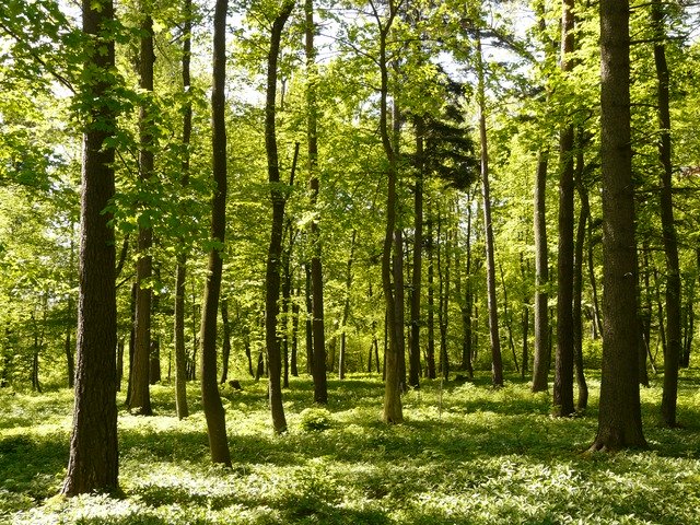
Arkansas's temperate deciduous forest is divided into three broad ecoregions; the Ozark, Ouachita-Appalachian Forests, the Mississippi Alluvial and Southeast USA Coastal Plains, and the Southeastern USA Plains. The state is further divided into seven subregions: the Arkansas Valley, Boston Mountains, Mississippi Alluvial Plain, Mississippi Valley Loess Plain, Ozark Highlands, Ouachita Mountains, and the South Central Plains. A 2010 United States Forest Service survey determined 18,720,000 أكرs (7,580,000 ها) of Arkansas's land is forestland, or 56% of the state's total area. Dominant species in Arkansas's forests include Quercus (oak), Carya (hickory), Pinus echinata (shortleaf pine) and Pinus taeda (loblolly pine).
Arkansas's plant life varies with its climate and elevation. The pine belt stretching from the Arkansas delta to Texas consists of dense oak-hickory-pine growth. Lumbering and paper milling activity is active throughout the region. In eastern Arkansas, one can find Taxodium (cypress), Quercus nigra (water oaks), and hickories with their roots submerged in the Mississippi Valley bayous indicative of the deep south. Nearby Crowley's Ridge is the only home of the tulip tree in the state, and generally hosts more northeastern plant life such as the beech tree. The northwestern highlands are covered in an oak-hickory mixture, with Ozark white cedars, cornus (dogwoods), and Cercis canadensis (redbuds) also present. The higher peaks in the Arkansas River Valley play host to scores of ferns, including the Woodsia scopulina and Adiantum (maidenhair fern) on Mount Magazine.
الطقس
| درجات الحرارة العظمى والصغرى في ولاية أركنساس | ||||||||||||
| المدينة | Jan | Feb | Mar | Apr | May | Jun | Jul | Aug | Sep | Oct | Nov | Dec |
|---|---|---|---|---|---|---|---|---|---|---|---|---|
| فورت سميث | 48/28 | 55/33 | 64/41 | 73/49 | 80/59 | 88/67 | 93/71 | 93/70 | 85/63 | 75/50 | 61/40 | 51/31 |
| لتل روك | 50/31 | 56/35 | 64/43 | 73/50 | 81/59 | 89/68 | 93/72 | 92/70 | 85/64 | 75/52 | 62/42 | 52/34 |
التاريخ
عاش الهنود في منطقة أركنساس لعدة مئات من السنين قبل وصول الأوروبيين إليها. في عام 1541 اتى إلى منطقة أركنساس هرناندودى سوتو، المستكشف الاسباني. ادعى رينيه روبرت كاڤلييه وسيور دى لاسال في عام 1682 حتى وادي المسيسيبي لفرنسا. وقد ضمت المنطقة التي زعما ملكيتها، والتي سمياها لويزيانا، أرْكنساس. وآلت السيطرة على أراضي لويزيانا إلى أسبانيا عام 1763، ثم عادت إلى فرنسا عام 1800.
شراء الولايات المتحدة لها
Napoleon Bonaparte sold French Louisiana to the United States in 1803, including all of Arkansas, in a transaction known today as the Louisiana Purchase. French soldiers remained as a garrison at Arkansas Post. Following the purchase, the balanced give-and-take relationship between settlers and Native Americans began to change all along the frontier, including in Arkansas. Following a controversy over allowing slavery in the territory, the Territory of Arkansas was organized on July 4, 1819. Gradual emancipation in Arkansas was struck down by one vote, the Speaker of the House Henry Clay, allowing Arkansas to organize as a slave territory. واشترت الولايات المتحدة الأراضي عام 1803. وفي 15 يونيو1836، أصبحت أركنساس ولاية ضمن الولايات المتحدة الأمريكية.
حاربت أركنساس مع المتحالفين أثناء الحرب الأهلية الأمريكية (1861 – 1865). في عامي 1864 و1865م، كان للولاية حكومة اتحادية وحكومة تحالفية. في عام 1874م، أدى نزاع على منصب الحاكم إلى العنف.
في القرنين التاسع عشر والعشرين، زاد النموالاقتصادي بالولاية. وازدهر بناء السكك الحديدية والزراعة والصناعة. افتتحت مناجم البوكسيت ونمت زراعة فول الصويا، وتم اكتشاف النفط بعد الحرب العالمية الثانية (1939- 1945) بوقت وجيز، بدأت الولاية تنتقل من الاقتصاد الزراعي إلى الاقتصاد الصناعي. في عام 1957، أوفد الرئيس دوايت أيزنهاور القوات الأمريكية إلى لتل روك لكي يطبق بالقوة أمر المحكمة بإلزام المدرسة العليا المركزية بالسماح للطلبة السود بالالتحاق بها.
في عام 1992، تم انتخاب الديمقراطي بل كلينتون حاكم أركنساس لخمس فترات متتالية رئيساً للولايات المتحدة، وأعيد انتخابه رئيساً للولايات المتحدة، وأعيد انتخابه رئيساً لفترة ثانية في عام 1996م.
التوزيع السكاني
| التعداد تاريخياً | |||
|---|---|---|---|
| الإحصاء | التعداد | %± | |
| 1810 | 1٬062 | ||
| 1820 | 14٬273 | 1244.0% | |
| 1830 | 30٬388 | 112.9% | |
| 1840 | 97٬574 | 221.1% | |
| 1850 | 209٬897 | 115.1% | |
| 1860 | 435٬450 | 107.5% | |
| 1870 | 484٬471 | 11.3% | |
| 1880 | 802٬525 | 65.6% | |
| 1890 | 1٬128٬211 | 40.6% | |
| 1900 | 1٬311٬564 | 16.3% | |
| 1910 | 1٬574٬449 | 20.0% | |
| 1920 | 1٬752٬204 | 11.3% | |
| 1930 | 1٬854٬482 | 5.8% | |
| 1940 | 1٬949٬387 | 5.1% | |
| 1950 | 1٬909٬511 | -2.0% | |
| 1960 | 1٬786٬272 | -6.5% | |
| 1970 | 1٬923٬295 | 7.7% | |
| 1980 | 2٬286٬435 | 18.9% | |
| 1990 | 2٬350٬725 | 2.8% | |
| 2000 | 2٬673٬400 | 13.7% | |
| تقديري 2008 | 2٬855٬390 | 6.8% | |
الدين
-
مسيحيون: 86.0%
-
پروتستانت: 78.0%
- Baptist: 39.0%
- Methodist: 9.0%
- Pentecostal: 6.0%
- Church of Christ: 6.0%
- Assemblies of God: 3.0%
- پروتستانت آخرون: 15.0%
- Roman Catholic: 7.0%
- مسيحية أرثوذكسية: <1.0%
- مسيحيون آخرون: <1.0%
-
پروتستانت: 78.0%
- ديانات أخرى: <1.0%
- بلا ديانة: 14.0%
- يهود: .01%
الإقتصاد
يعمل العمال بأركنساس في التصنيع الخفيف أكثر من أي صناعة أخرى. والنشاط التصنيعي الرئيسي هومعالجة الأغذية. والمراكز الرئيسية للتصنيع هي فورت سْميث وليتيل روك شمالي منطقة ليتيل روك. وتستقطب تجارة الجملة والتجزئة عددًا كبيرًا من الناس، وليتيل روك وفورت سميث هما المركزان الرئيسيان لتجارة التجزئة.
تتصدَّر أركنساس بقية الولايات في تربية الدجاج الصغير (الدجاج منخمسة إلى 12 أسبوعًا) في الولايات المتحدة. كما أنها تغرس أرزًا أكثر من أي ولاية أخرى. وتقف أركنساس في القمة بين منتجي القطن وفول الصويا. كما تملك الولاية أيضًا مخزونًا من النفط والغاز الطبيعي والبوكسيت (مادة يؤخذ منها الألومنيوم). وأركنساس هي المنتج الرئيسي للبروم (عنصر كيميائي غير معدني).
الضرائب
النقل
- U.S. Route 49
- U.S. Route 59
- U.S. Route 61
- U.S. Route 62
- U.S. Route 63
- U.S. Route 64
- U.S. Route 65
- U.S. Route 67
- U.S. Route 70
- U.S. Route 71
- U.S. Route 82
- U.S. Route 165
- U.S. Route 167
- U.S. Route 270
- U.S. Route 271
- U.S. Route 278
- U.S. Route 371
- U.S. Route 412
- U.S. Route 425
القانون والحكومة
| السنة | جمهوري | ديموقرطي |
|---|---|---|
| 2008 | 58.72% 638,017 | 38.86% 422,310 |
| 2004 | 54.31% 572,898 | 44.55% 469,953 |
| 2000 | 51.31% 472,940 | 45.86% 422,768 |
| 1996 | 36.80% 325,416 | 53.74% 475,171 |
| 1992 | 35.48% 337,324 | 53.21% 505,823 |
| 1988 | 56.37% 466,578 | 42.19% 349,237 |
| 1984 | 60.47% 534,774 | 38.29% 338,646 |
| 1980 | 48.13% 403,164 | 47.52% 398,041 |
| 1976 | 34.93% 268,753 | 64.94% 499,614 |
| 1972 | 68.82% 445,751 | 30.71% 198,899 |
| 1968* | 31.01% 189,062 | 30.33% 184,901 |
| 1964 | 43.41% 243,264 | 56.06% 314,197 |
| 1960 | 43.06% 184,508 | 50.19% 215,049 |
| *State won by George Wallace of the American Independent Party, at 38.65%, or 235,627 votes | ||
المناطق الحضرية
انظر أيضا المناطق الحضرية في أركنساس.
أكبر المدن زيادة عن 10,000 من 2007
| الترتيب | المدينة | 2007–2008 سكان | ||
|---|---|---|---|---|
| 1. | ليتل روك | 189,515 | الوسط | |
| 2. | Fort Smith | 84,716 | شمال الغرب | |
| 3. | Fayetteville | 73,372 | شمال الغرب | |
| 4. | Springdale | 68,180 | شمال الغرب | |
| 5. | Jonesboro | 63,690 | شمال الغرب | |
| 6. | North Little Rock | 59,430 | الوسط | |
| 7. | Conway | 57,544 | الوسط | |
| 8. | Rogers | 56,726 | شمال الغرب | |
| 9. | Pine Bluff | 50,408 | جنوب الشرق | |
| 10. | Hot Springs | 39,467 | جنوب الغرب | |
| 11. | Bentonville | 35,526 | شمال الغرب | |
| 12. | Jacksonville | 31,351 | الوسط | |
| 13. | Texarkana | 30,087 | جنوب الغرب | |
| 14. | Benton | 29,452 | الوسط | |
| 15. | Russellville | 27,602 | الوسط | |
| 16. | West Memphis | 27,070 | شمال الغرب | |
| 17. | Paragould | 24,800 | شمال الغرب | |
| 18. | Sherwood | 24,542 | الويط | |
| 19. | Cabot | 23.614 | الويط | |
| 20. | Van Buren | 22,543 | شمال الغرب | |
| 21. | Searcy | 22,299 | الوسط | |
| 22. | El Dorado | 19,905 | جنوب الشرق | |
| 23. | Bella Vista | 16,388 | شمال الغرب | |
| 24. | Maumelle | 16,201 | الوسط | |
| 25. | Blytheville | 16,105 | شمال الشرق | |
| 26. | Bryant | 15,040 | الوسط | |
| 27. | Siloam Springs | 14,825 | شمال الغرب | |
| 28. | Forrest City | 13,281 | شمال الغرب | |
| 29. | Harrison | 13,108 | شمال الغرب | |
| 30. | Mountain Home | 12,592 | شمال الغرب | |
| 31. | Marion | 12,217 | شمال الغرب | |
| 32. | Magnolia | 11,766 | جنوب الغرب | |
| 33. | Camden | 11,512 | جنوب الشرق | |
| 34. | Arkadelphia | 11,130 | جنوب الشرق | |
| 35. | Hope | 10,378 | جنوب الغرب |
أهم المدن والبلدات
الأسماءبالخط العريض عدد سكانها أكثر من 20,000.
|
|
التعليم
Public school districts
- List of school districts in Arkansas
مراكز البحث
- National Center for Toxicological Research
- University of Arkansas Division of Agriculture
الكليات والجامعات
- Arkansas Baptist College
-
Arkansas State University System
- Arkansas State University - Jonesboro
- Arkansas State University - Mountain Home
- Arkansas Tech University
- Central Baptist College
- Harding University
- Henderson State University
- Hendrix College
- John Brown University
- Lyon College
- Ouachita Baptist University
- Ozarka College
- Philander Smith College
- Southern Arkansas University
-
University of Arkansas System
- University of Arkansas, Fayetteville
- University of Arkansas at Fort Smith
- University of Arkansas at Little Rock
- University of Arkansas for Medical Sciences
- University of Arkansas at Monticello
- University of Arkansas at Pine Bluff
- University of Central Arkansas
- University of the Ozarks
- Williams Baptist College
أشهر المواطنين
- بيل كلينتون
انظر أيضا
- موضوعات عن أركنساس
ملاحظات
- ^ Elevation adjusted to North American Vertical Datum of 1988.
- ^ The Geographic Names Index System (GNIS) of the United States Geological Survey (USGS) indicates that the official name of this feature is Magazine Mountain, not "Mount Magazine". Although not a hard and fast rule, generally "Mount X" is used for a peak and "X Mountain" is more frequently used for ridges, which better describes this feature. Magazine Mountain appears in the GNIS as a ridge, with Signal Hill identified as its summit. "Mount Magazine" is the name used by the Arkansas Department of Parks and Tourism, which follows what the locals have used since the area was first settled.
- ^
The region was organized as the Territory of Arkansaw on July 4, 1819, but the territory was admitted to the United States as the state of Arkansas on June 15, 1836. The name was historically pronounced //, //, and several other variants. The residents of Arkansas have called themselves either "Arkansans" or "Arkansawyers". In 1881, the Arkansas General Assembly passed the following concurrent resolution, now Arkansas Code 1 April 105:
Despite this, the state's name is still frequently mispronounced, especially by non-Americans; in fact, it is spelled in Cyrillic with the pronunciation.Whereas, confusion of practice has arisen in the pronunciation of the name of our state and it is deemed important that the true pronunciation should be determined for use in oral official proceedings.
And, whereas, the matter has been thoroughly investigated by the State Historical Society and the Eclectic Society of Little Rock, which have agreed upon the correct pronunciation as derived from history, and the early usage of the American immigrants.
Be it therefore resolved by both houses of the General Assembly, that the only true pronunciation of the name of the state, in the opinion of this body, is that received by the French from the native Indians and committed to writing in the French word representing the sound. It should be pronounced in three (3) syllables, with the final "s" silent, the "a" in each syllable with the Italian sound, and the accent on the first and last syllables. The pronunciation with the accent on the second syllable with the sound of "a" in "man" and the sounding of the terminal "s" is discouraged by Arkansans.
Citizens of the state of Kansas often pronounce the Arkansas River as //, in a manner similar to the common pronunciation of the name of their state.
المصادر
- ^ "United States Summary: 2010, Population and Housing Unit Counts, 2010 Census of Population and Housing" (PDF). United States Census Bureau. September 2012. p. 89. Retrieved February 1, 2020.
- ^ "Mag". NGS data sheet. U.S. National Geodetic Survey. Retrieved October 20, 2011.
- ^ "Elevations and Distances in the United States". United States Geological Survey. 2001. Archived from the original on October 15, 2011. Retrieved October 21, 2011.
- ^ "Magazine Mountain". Geographic Names Information System. United States Geological Survey. Retrieved January 2, 2013.
- ^ "Signal Hill". Geographic Names Information System. United States Geological Survey. Retrieved January 2, 2013.
- ^ Blevins 2009, p. 2.
- ^ Bright, William (2007). . Norman: University of Oklahoma Press. p. 47. ISBN .
- ^ "Code" (1‐4‐105). AR, US: Assembly. Archived from the original (official text) on September 24, 2011.
- ^ Gambrell, John (March 13, 2007). "Senate gives support to possessive form of Arkansas". Arkansas Democrat Gazette. Retrieved June 28, 2012.
- ^ (PDF) (PDF). 1:10000000. United States Environmental Protection Agency. Retrieved July 5, 2012.
- ^ (PDF) (PDF). United States Environmental Protection Agency. Retrieved July 5, 2012.
- ^ "Forest Inventory and Analysis". United States Forest Service, Southern Research Station. 2010. Archived from the original (XLS) on December 1, 2012. Retrieved July 5, 2012.
- ^ "Proceedings of the Symposium on Arkansas Forests: A Conference on the Results of the Recent Forest Survey of Arkansas". United States Forest Service. May 30–31, 1997. p. 74.
- ^ Dale, Jr, Edward E.; Ware, Stewart (April–June 2004). "Distribution of Wetland Tree Species in Relation to a Flooding Gradient and Backwater versus Streamside Location in Arkansas, U.S.A". Journal of the Torrey Botanical Society. 131 (2): 177–186. doi:10.2307/4126919. JSTOR 4126919.
- ^ Federal Writers' Project 1987, p. 13.
- ^ Federal Writers' Project 1987, p. 12.
- ^ Federal Writers' Project 1987, pp. 12–13.
- ^ Federal Writers' Project 1987, pp. 13–14.
- ^ http://www.ustravelweather.com/weather-arkansas/
- ^ Arnold et al. 2002, p. 79.
- ^ Johnson 1965, p. 58.
-
^ خطأ استشهاد: وسم
<ref>غير سليم؛ لا نص تم توفيره للمراجع المسماة08CenEst
- الموسوعة المعهدية الكاملة
قراءات إضافية
- Blair, Diane D. & Jay Barth Arkansas Politics & Government: Do the People Rule? (2005)
- Deblack, Thomas A. With Fire and Sword: Arkansas, 1861–1874 (2003)
- Donovan, Timothy P. and Willard B. Gatewood Jr., eds. The Governors of Arkansas (1981)
- Dougan, Michael B. Confederate Arkansas (1982),
- Duvall, Leland. ed., Arkansas: Colony and State (1973)
- Fletcher, John Gould. Arkansas (1947)
- (1906), full length history of era; Dunning School approach; 570 pp; ch 13 on Arkansas
- Hanson, Gerald T. and Carl H. Moneyhon. Historical Atlas of Arkansas (1992)
- Key, V. O. Southern Politics (1949)
- Kirk, John A., Redefining the Color Line: Black Activism in Little Rock, Arkansas, 1940–1970 (2002).
- McMath, Sidney S. Promises Kept (2003)
- Moore, Waddy W. ed., Arkansas in the Gilded Age, 1874–1900 (1976).
- Peirce, Neal R. The Deep South States of America: People, Politics, and Power in the Seven Deep South States (1974)
- Thompson, George H. Arkansas and Reconstruction (1976)
- Whayne, Jeannie M. et al. Arkansas: A Narrative History (2002)
- Whayne, Jeannie M. Arkansas Biography: A Collection of Notable Lives (2000)
- White, Lonnie J. Politics on the Southwestern Frontier: Arkansas Territory, 1819–1836 (1964)
- Williams, C. Fred. ed. A Documentary History Of Arkansas (2005)
- WPA., Arkansas: A Guide to the State (1941)
وصلات خارجية
تعريفات قاموسية في ويكاموس
خط من فهم الخط
اقتباسات من فهم الاقتباس
نصوص مصدرية من فهم المصادر
صور وملفات صوتية من كومونز
أخبار من فهم الأخبار.
- Official State website
- أركنسا at the Open Directory Project
- Arkansas State Code (the state statutes of Arkansas)
- Arkansas State Databases - Annotated list of searchable databases produced by Arkansas state agencies and compiled by the Government Documents Roundtable of the American Library Association.
- Arkansas State Facts
- Official State tourism website
- The Encyclopedia of Arkansas History & Culture
- Energy & Environmental Data for Arkansas
- U.S. Census Bureau
- USGS real-time, geographic, and other scientific resources of Arkansas
Coordinates: