مقاطعة إنيو، كاليفورنيا
County of Inyo | ||
|---|---|---|
County | ||
|
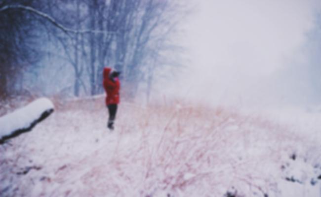
Wildflowers blooming in Death Valley after an unusually wet winter
| ||
| ||
|
Location in the state of California
| ||
|
California's location in the الولايات المتحدة
| ||
| Country |
|
|
| State |
|
|
| Region | Eastern California | |
| Founded | 1866 | |
| السَمِيْ | "dwelling place of the great spirit" in Mono language | |
| County seat | Independence | |
| Largest city | Bishop | |
| الحكم | ||
| • Board of Supervisors | Supervisors
|
|
| • 34th State Assembly District | Connie Conway (R) | |
| • 18th State Senate District | Jean Fuller (R) | |
| • 8th U.S. House District | Paul Cook (R) | |
| المساحة | ||
| • الإجمالية | 10٬227 ميل² (26٬490 كم²) | |
| • البر | 10٬181 ميل² (26٬370 كم²) | |
| • الماء | 46 ميل² (120 كم²) | |
| التعداد(2010) | ||
| • الإجمالي | 18٬546 | |
| • الكثافة | 1٫8/sq mi (0٫70/km2) | |
| منطقة التوقيت | Pacific Standard Time (التوقيت العالمي المنسق-8) | |
| • الصيفي | Pacific Daylight Time (UTC-7) | |
| المسقط الإلكتروني | www.inyocounty.us | |
مقاطعة إنيو بالإنگليزية: Inyo County هي إحدى مقاطعات ولاية كاليفورنيا في الولايات المتحدة الأمريكية.
المقاطعات المجاورة
- Mono County - north
- Esmeralda County, Nevada - northeast
- Nye County, Nevada - east
- Clark County, Nevada - southeast
- San Bernardino County - south
- Kern County - southwest
- Tulare County - west
- Fresno County - west
البحيرات
- Weir Lake
- Camp Lake
- Inconsolable Lake
- Cottonwood Lakes
- Wishbone Lake
- Rock Creek Lake
- Granite Lake
- Robinson Lake
National protected areas
- Death Valley National Park (part)
- Inyo National Forest (part)
- Manzanar National Historic Site
Except as noted, the wilderness areas are managed solely by the Bureau of Land Management, and lie entirely within Inyo County:
- Argus Range Wilderness
- Coso Range Wilderness
- Darwin Falls Wilderness
- Death Valley Wilderness (part)
- Funeral Mountains Wilderness
- Golden Trout Wilderness (part)
- Ibex Wilderness
- Inyo Mountains Wilderness (part)
- John Muir Wilderness (part)
- Malpais Mesa Wilderness
- Manly Peak Wilderness
- Nopah Range Wilderness
- Owens Peak Wilderness (part)
- Pahrump Valley Wilderness (part)
- Piper Mountain Wilderness
- Resting Spring Range Wilderness
- Sacatar Trail Wilderness (part)
- Saddle Peak Hills Wilderness (part)
- South Nopah Range Wilderness
- South Sierra Wilderness (part)
- Surprise Canyon Wilderness
- Sylvania Mountains Wilderness
وادي الموت، المنتزه الوطني
المطارات
Bishop Airport, Independence Airport, Lone Pine Airport and Shoshone Airport are general aviation airports located near their respective cities. Stovepipe Wells Airport and Furnace Creek Airport are located in Death Valley National Park.
الجريمة
The following table includes the number of incidents reported and the rate per 1,000 persons for each type of offense.
| Population and crime rates | ||
|---|---|---|
| Population | 18,457 | |
| Violent crime | 80 | 4.33 |
| Homicide | 2 | 0.11 |
| Forcible rape | 11 | 0.60 |
| Robbery | 7 | 0.38 |
| Aggravated assault | 60 | 3.25 |
| Property crime | 154 | 8.34 |
| Burglary | 75 | 4.06 |
| Larceny-theft | 177 | 9.59 |
| Motor vehicle theft | 18 | 0.98 |
| Arson | 1 | 0.05 |
Cities by population and crime rates
| Cities by population and crime rates | ||||||||
|---|---|---|---|---|---|---|---|---|
| City | Population | Violent crimes | Violent crime rate per 1,000 persons |
Property crimes | Property crime rate per 1,000 persons |
|||
| Bishop | 3,900 | 16 | 4.10 | 137 | 35.13 | |||
الديمغرافيا
2011
| Population, race, and income | |||||
|---|---|---|---|---|---|
| Total population | 18,457 | ||||
| White | 14,339 | 77.7% | |||
| Black or African American | 204 | 1.1% | |||
| American Indian or Alaska Native | 1,846 | 10.0% | |||
| Asian | 271 | 1.5% | |||
| Native Hawaiian or other Pacific Islander | 66 | 0.4% | |||
| Some other race | 1,374 | 7.4% | |||
| Two or more races | 357 | 1.9% | |||
| Hispanic or Latino (of any race) | 3,445 | 18.7% | |||
| Per capita income | $27,532 | ||||
| Median household income | $49,571 | ||||
| Median family income | $68,204 | ||||
Places by population, race, and income
| Places by population and race | ||||||||
|---|---|---|---|---|---|---|---|---|
| Place | Type | Population | White | Other |
Asian | Black or African American |
Native American |
Hispanic or Latino (of any race) |
| Big Pine | CDP | 1,563 | 77.4% | 7.8% | 1.5% | 1.0% | 12.3% | 11.5% |
| Bishop | City | 3,839 | 78.5% | 17.6% | 2.6% | 0.1% | 1.2% | 31.2% |
| Cartago | CDP | 84 | 100.0% | 0.0% | 0.0% | 0.0% | 0.0% | 0.0% |
| Darwin | CDP | 32 | 100.0% | 0.0% | 0.0% | 0.0% | 0.0% | 0.0% |
| Dixon Lane-Meadow Creek | CDP | 2,800 | 86.1% | 11.3% | 0.0% | 0.0% | 2.5% | 23.0% |
| Furnace Creek | CDP | 115 | 79.1% | 0.0% | 0.0% | 0.0% | 20.9% | 8.7% |
| Homewood Canyon | CDP | 79 | 100.0% | 0.0% | 0.0% | 0.0% | 0.0% | 0.0% |
| Independence | CDP | 520 | 73.8% | 7.1% | 0.6% | 2.1% | 16.3% | 7.9% |
| Keeler | CDP | 88 | 100.0% | 0.0% | 0.0% | 0.0% | 0.0% | 0.0% |
| Lone Pine | CDP | 2,076 | 79.1% | 5.3% | 3.0% | 1.3% | 11.2% | 18.3% |
| Mesa | CDP | 442 | 77.4% | 17.0% | 5.7% | 0.0% | 0.0% | 16.1% |
| Olancha | CDP | 245 | 52.2% | 47.8% | 0.0% | 0.0% | 0.0% | 38.8% |
| Pearsonville | CDP | 6 | 100.0% | 0.0% | 0.0% | 0.0% | 0.0% | 0.0% |
| Round Valley | CDP | 396 | 87.4% | 4.5% | 0.5% | 0.0% | 7.6% | 14.6% |
| Shoshone | CDP | 36 | 94.4% | 0.0% | 0.0% | 0.0% | 5.6% | 8.3% |
| Tecopa | CDP | 98 | 100.0% | 0.0% | 0.0% | 0.0% | 0.0% | 5.1% |
| Trona | CDP | 0 | 0.0% | 0.0% | 0.0% | 0.0% | 0.0% | 0.0% |
| Valley Wells | CDP | 0 | 0.0% | 0.0% | 0.0% | 0.0% | 0.0% | 0.0% |
| West Bishop | CDP | 3,019 | 89.7% | 4.1% | 1.5% | 4.3% | 0.4% | 15.8% |
| Wilkerson | CDP | 484 | 100.0% | 0.0% | 0.0% | 0.0% | 0.0% | 0.0% |
| Places by population and income | |||||
|---|---|---|---|---|---|
| Place | Type | Population | Per capita income | Median household income | Median family income |
| Big Pine | CDP | 1,563 | $28,276 | $63,269 | $75,500 |
| Bishop | City | 3,839 | $27,205 | $34,258 | $61,574 |
| Cartago | CDP | 84 | $37,211 | $44,293 | |
| Darwin | CDP | 32 | $18,525 | $33,929 | |
| Dixon Lane-Meadow Creek | CDP | 2,800 | $26,640 | $56,620 | $68,385 |
| Furnace Creek | CDP | 115 | $30,670 | $31,000 | $92,813 |
| Homewood Canyon | CDP | 79 | $5,525 | $15,347 | |
| Independence | CDP | 520 | $26,418 | $43,750 | $64,044 |
| Keeler | CDP | 88 | $20,125 | $14,821 | $14,565 |
| Lone Pine | CDP | 2,076 | $20,995 | $35,938 | $48,214 |
| Mesa | CDP | 442 | $31,341 | $62,014 | $64,063 |
| Olancha | CDP | 245 | $20,648 | $37,250 | $102,802 |
| Pearsonville | CDP | 6 | |||
| Round Valley | CDP | 396 | $34,338 | $75,341 | $83,125 |
| Shoshone | CDP | 36 | $22,358 | $41,250 | $41,250 |
| Tecopa | CDP | 98 | $17,664 | $22,188 | $21,875 |
| Trona | CDP | 0 | |||
| Valley Wells | CDP | 0 | |||
| West Bishop | CDP | 3,019 | $33,802 | $79,219 | $95,208 |
| Wilkerson | CDP | 484 | $34,174 | $49,167 | $71,875 |
2010
| التعداد التاريخي | |||
|---|---|---|---|
| التعداد | Pop. | %± | |
| 1870 | 1٬956 | — | |
| 1880 | 2٬928 | 49٫7% | |
| 1890 | 3٬544 | 21�0% | |
| 1900 | 4٬377 | 23٫5% | |
| 1910 | 6٬974 | 59٫3% | |
| 1920 | 7٬031 | 0٫8% | |
| 1930 | 6٬555 | −6٫8% | |
| 1940 | 7٬625 | 16٫3% | |
| 1950 | 11٬658 | 52٫9% | |
| 1960 | 11٬684 | 0٫2% | |
| 1970 | 15٬571 | 33٫3% | |
| 1980 | 17٬895 | 14٫9% | |
| 1990 | 18٬281 | 2٫2% | |
| 2000 | 17٬945 | −1٫8% | |
| 2010 | 18٬546 | 3٫3% | |
| تقدير 2013 | 18٬467 | −0٫4% | |
1790-1960 1900-1990 1990-2000 2010-2013 | |||
The 2010 United States Census reported that Inyo County had a population of 18,546. The racial makeup of Inyo County was 13,741 (74.1%) White, 109 (0.6%) African American, 2,121 (11.4%) Native American, 243 (1.3%) Asian, 16 (0.1%) Pacific Islander, 1,676 (9.0%) from other races, and 640 (3.5%) from two or more races. Hispanic or Latino of any race were 3,597 persons (19.4%).
| Population reported at 2010 United States Census | |||||||||
|---|---|---|---|---|---|---|---|---|---|
Population |
more races |
or Latino (of any race) |
|||||||
| Inyo County | 18,546 | 13,741 | 109 | 2,121 | 243 | 16 | 1,676 | 640 | 3,597 |
Population |
more races |
or Latino (of any race) |
|||||||
| Bishop | 3,879 | 2,867 | 22 | 91 | 61 | 1 | 723 | 114 | 1,200 |
Population |
more races |
or Latino (of any race) |
|||||||
| Big Pine | 1,756 | 1,192 | 3 | 438 | 13 | 1 | 52 | 57 | 182 |
| Cartago | 92 | 63 | 0 | 7 | 0 | 0 | 11 | 11 | 16 |
| Darwin | 43 | 38 | 0 | 2 | 1 | 1 | 0 | 1 | 2 |
| Dixon Lane-Meadow Creek | 2,645 | 2,287 | 6 | 32 | 47 | 3 | 215 | 55 | 493 |
| Furnace Creek | 24 | 6 | 0 | 16 | 0 | 0 | 0 | 2 | 0 |
| Homewood Canyon | 44 | 37 | 0 | 0 | 0 | 0 | 5 | 2 | 6 |
| Independence | 669 | 493 | 6 | 98 | 8 | 1 | 28 | 35 | 93 |
| Keeler | 66 | 63 | 0 | 0 | 2 | 0 | 0 | 1 | 6 |
| Lone Pine | 2,035 | 1,334 | 6 | 205 | 17 | 1 | 376 | 96 | 694 |
| Mesa | 251 | 220 | 0 | 10 | 3 | 0 | 14 | 4 | 26 |
| Olancha | 192 | 133 | 0 | 4 | 8 | 0 | 38 | 9 | 47 |
| Pearsonville | 17 | 16 | 0 | 0 | 0 | 0 | 1 | 0 | 1 |
| Round Valley | 435 | 333 | 38 | 21 | 3 | 0 | 27 | 13 | 69 |
| Shoshone | 31 | 28 | 1 | 1 | 0 | 0 | 0 | 1 | 0 |
| Tecopa | 150 | 119 | 1 | 8 | 2 | 0 | 1 | 19 | 8 |
| Trona | 18 | 18 | 0 | 0 | 0 | 0 | 0 | 0 | 0 |
| Valley Wells | 0 | 0 | 0 | 0 | 0 | 0 | 0 | 0 | 0 |
| West Bishop | 2,607 | 2,373 | 10 | 28 | 45 | 1 | 72 | 78 | 261 |
| Wilkerson | 563 | 524 | 0 | 13 | 5 | 1 | 5 | 15 | 53 |
Population |
more races |
or Latino (of any race) |
|||||||
| All others not CDPs (combined) | 3,029 | 1,597 | 16 | 1,147 | 28 | 6 | 108 | 127 | 440 |
Politics
Voter registration statistics
| Population and registered voters | ||
|---|---|---|
| Total population | 18,457 | |
| Registered voters | 9,922 | 53.8% |
| Democratic | 3,066 | 30.9% |
| Republican | 4,271 | 43.0% |
| Democratic–Republican spread | -1,205 | -12.1% |
| American Independent | 414 | 4.2% |
| Green | 88 | 0.9% |
| Libertarian | 79 | 0.8% |
| Peace and Freedom | 29 | 0.3% |
| Americans Elect | 0 | 0.0% |
| Other | 46 | 0.5% |
| No party preference | 1,929 | 19.4% |
Cities by population and voter registration
| Cities by population and voter registration | |||||||
|---|---|---|---|---|---|---|---|
| City | Population | Registered voters |
Democratic | Republican | D–R spread | Other | No party preference |
| Bishop | 3,839 | 42.9% | 31.4% | 40.3% | -8.9% | 10.4% | 21.7% |
Overview
| Year | GOP | DEM | Others |
|---|---|---|---|
| 2008 | 53.1% 4,523 | 43.9% 3,743 | 2.9% 243 |
| 2004 | 59.1% 5,091 | 38.9% 3,350 | 2.0% 175 |
| 2000 | 60.3% 4,713 | 33.9% 2,652 | 5.8% 450 |
| 1996 | 51.8% 3,924 | 34.4% 2,601 | 13.8% 1,044 |
| 1992 | 43.6% 3,689 | 31.8% 2,695 | 24.6% 2,080 |
| 1988 | 64.3% 5,042 | 33.9% 2,653 | 1.8% 142 |
| 1984 | 70.3% 5,863 | 28.3% 2,360 | 1.4% 115 |
| 1980 | 64.8% 5,201 | 25.9% 2,080 | 9.3% 746 |
| 1976 | 58.2% 3,905 | 39.3% 2,635 | 2.5% 166 |
| 1972 | 68.1% 4,873 | 28.0% 2,006 | 3.9% 280 |
| 1968 | 54.5% 3,641 | 34.6% 2,314 | 11.0% 732 |
| 1964 | 46.5% 2,751 | 53.4% 3,161 | 0.1% 3 |
| 1960 | 54.7% 2,962 | 45.1% 2,443 | 0.3% 15 |
| 1956 | 66.2% 3,524 | 33.5% 1,782 | 0.3% 18 |
| 1952 | 68.9% 3,819 | 30.6% 1,698 | 0.5% 28 |
| 1948 | 55.8% 2,135 | 40.2% 1,539 | 4.0% 153 |
| 1944 | 50.6% 1,699 | 49.1% 1,647 | 0.3% 9 |
| 1940 | 44.5% 1,483 | 54.7% 1,820 | 0.8% 27 |
| 1936 | 36.5% 912 | 62.4% 1,560 | 1.2% 29 |
| 1932 | 30.9% 698 | 64.6% 1,459 | 4.5% 101 |
| 1928 | 57.4% 1,206 | 41.0% 861 | 1.7% 35 |
| 1924 | 47.5% 950 | 12.8% 256 | 39.7% 793 |
| 1920 | 57.2% 1,195 | 32.7% 682 | 8.8% 212 |
| Election results from statewide races | ||
|---|---|---|
| Year | Office | Results |
| 2010 | Governor | Whitman 48.9 - 43.2% |
| Lieutenant Governor | Maldonado 50.5 - 35.5% | |
| Secretary of State | Dunn 51.0 - 37.9% | |
| Controller | Strickland 45.6 - 42.7% | |
| Treasurer | Walters 47.9 - 43.1% | |
| Attorney General | Cooley 56.4 - 31.4% | |
| Insurance Commissioner | Villines 51.1 - 34.1% | |
Inyo is a strongly الجمهوري county in Presidential and congressional elections. The last Democrat to win a majority in the county was Lyndon Johnson in 1964.
مواقع بارزة
- Mushroom Rock
- Five Bridges
Communities
City
- Bishop
Census-designated places
- Big Pine
- Cartago
- Darwin
- Dixon Lane-Meadow Creek
- Furnace Creek
- Homewood Canyon
- Independence
- Keeler
- Lone Pine
- Mesa
- Olancha
- Pearsonville
- Round Valley
- Shoshone
- Tecopa
- Valley Wells
- West Bishop
- Wilkerson
Unincorporated communities
- Calvada Springs
- Deep Springs
- Laws
See also
- National Register of Historic Places listings in Inyo County, California
ملاحظات
- ^ Only larceny-theft cases involving property over $400 in value are reported as property crimes.
- ^ Other = Some other race + Two or more races
- ^ Native American = Native Hawaiian or other Pacific Islander + American Indian or Alaska Native
- ^ Percentage of registered voters with respect to total population. Percentages of party members with respect to registered voters follow.
الهامش
- ^ U.S. Census Bureau. American Community Survey, 2011 American Community Survey 5-Year Estimates, Table B02001. American FactFinder. Retrieved 2013-10-26.
- ^ Office of the Attorney General, Department of Justice, State of California. Table 11: Crimes – 2009. Retrieved 2013-11-14.
- ^ United States Department of Justice, Federal Bureau of Investigation. Crime in the United States, 2012, Tableثمانية (California). Retrieved 2013-11-14.
- ^ U.S. Census Bureau. American Community Survey, 2011 American Community Survey 5-Year Estimates, Table B03003. American FactFinder. Retrieved 2013-10-26.
- ^ U.S. Census Bureau. American Community Survey, 2011 American Community Survey 5-Year Estimates, Table B19301. American FactFinder. Retrieved 2013-10-21.
- ^ U.S. Census Bureau. American Community Survey, 2011 American Community Survey 5-Year Estimates, Table B19013. American FactFinder. Retrieved 2013-10-21.
- ^ U.S. Census Bureau. American Community Survey, 2011 American Community Survey 5-Year Estimates, Table B19113. American FactFinder. Retrieved 2013-10-21.
- ^ U.S. Census Bureau. American Community Survey, 2011 American Community Survey 5-Year Estimates. American FactFinder. Retrieved 2013-10-21.
- ^ U.S. Census Bureau. American Community Survey, 2011 American Community Survey 5-Year Estimates, Table B01003. American FactFinder. Retrieved 2013-10-21.
- ^ Data unavailable
- ^ "U.S. Decennial Census". United States Census Bureau. Retrieved May 26, 2014.
- ^ "Historical Census Browser". University of Virginia Library. Retrieved May 26, 2014.
- ^ "Population of Counties by Decennial Census: 1900 to 1990". United States Census Bureau. Retrieved May 26, 2014.
- ^ "Census 2000 PHC-T-4. Ranking Tables for Counties: 1990 and 2000" (PDF). United States Census Bureau. Retrieved May 26, 2014.
-
^ خطأ استشهاد: وسم
<ref>غير سليم؛ لا نص تم توفيره للمراجع المسماةQF - ^ نطقب:USCensus2010CA
- ^ California Secretary of State. February 10, 2013 - Report of Registration. Retrieved 2013-10-31.
وصلات خارجية
| مشاع الفهم فيه ميديا متعلقة بموضوع Inyo County, California. |
- Official website
- Inyo County Office of Education
- Inyo County Tourism website
نطقب:Cities of Inyo County, California
|
ولاية كاليفورنيا |
|
|---|---|
| المواضيع |
المناخ | الثقافة | الأنطقيم | الإقتصاد | الإنتخابات | الجغرافيا | الحكومة | التاريخ السابق | التاريخ الحديث | السياسة | كاليفورنيون |
| المناطق |
أنتلوپ ڤالي | بيگ سور | كاسكيد رينج | ساحل الأوسط | سنترال ڤالي | جزر القناة | وادي كواتشيلا | وادي كونهو| وادي كوكامونگا | وادي الموت | شرق خليج سان فرانسيسكو| شرق كاليفورنيا | المثلث اللازوردي | بلد المضى | الحوض العظيم | لوس أنجلس الكبرى | إنلاند إمپاير | بحيرة تاهو| حوض لوس أنجلس | موهاڤا | شمال خليج سان فرانسيسكو| الساحل الشمالي | شمال كاليفورنيا | أونز ڤالي | شبه الجزيرة | پومونا ڤالي | ردوود إمپاير | نهر الروسي | ساكرامنتوڤالي | وادي سان فرناندو| منطقة خليج سان فرانسيسكو| وادي سان هواكين | وادي سانتا كلاريتا | شاستا كاسكيد | سييرا نـِڤادا | سليكون ڤالي | جنوب خليج سان فرانسيسكو| جنوب كاليفورنيا | تيك كوست | تراي-ڤالي | بلد النبيذ، كاليفورنيا | يوسميتي |
| المناطق الحضرية |
بيكرزفيلد | تشيكو| إل سنترو| فرزنو| لوس أنجلوس–لونگ بيتش–گلنديل | مودستو| مرسد | ناپا | أوكلاند–فريمونت–هايوارد | أوكسنارد، كاليفورنيا–ثاوزند اوكس–ڤنتورا | ردنگ | ريڤرسايد–سان برناردينو–أونتاريو| ساكرامنتو–روزفيل | ساليناس | سان دييگو–كارلسباد–سان ماركوس | سان فرانسيسكو–سان ماتيو–ريدوود سيتي | سان هوزيه–صنيڤيل–سانتا كلارا | سانتا أنا–أنهايم–إرڤاين | سانتا باربارا–سانتا ماريا | سانتا كروز–واتسونفيل | سانتا روزا–پتالوما | ستكتون | ڤاليهو–فيرفيلد | فيسالايا–پورترڤيل | يوبا سيتي |
| مقاطعات |
ألاميدا | ألپاين | أمادور | بوت | كالافيراس | كولوسا | كونترا كوستا | دل نورتى | إل دورادو| فرزنو| گلن | همبولت | إمپريال | إنيو| كيرن | كينگز | ليك | لاسين | لوس أنجلس | ماديرا | مارين | ماريپوسا | مندوسينو| مرسد | مودوك | مونو| مونتري | ناپا | نـِڤادا | اورانج | پليسر | بلوماس | ريڤرسايد | ساكرامنتو| سان بنيتو| سان برناردينو| سان دييگو| سان فرانسيسكو| سان هواكين | سان لويس أوبيسپو| سان ماتيو| سانتا باربرا | سانتا كلارا | سانتا كروز | شاستا | سييرا | سيسكيو| سولانو| سونوما | ستانيسلوس | سوتر | تيهاما | ترينيتي | تولير | توالومي | ڤنتورا | يولو| يوبا |