گريت يارموث
| Great Yarmouth | |
|---|---|
|
Great Yarmouth Town Hall, Hall Quay (opened: 1883; architect: J.B. Pearce) | |
| Area | 17.47 kم2 (6.75 ميل2) |
| Population | 70٬234 |
| • Density | 4,020/كم2 (10,400/ميل2) |
| OS grid reference | TG5207 |
| District |
|
| Shire county |
|
| Country | England |
| Sovereign state | United Kingdom |
| Post town | GREAT YARMOUTH |
| Postcode district | NR30 (north), NR31 (south) |
| Dialling code | +44 (0)1493 |
| EU Parliament | شرق إنگلترة |
| UK Parliament |
|
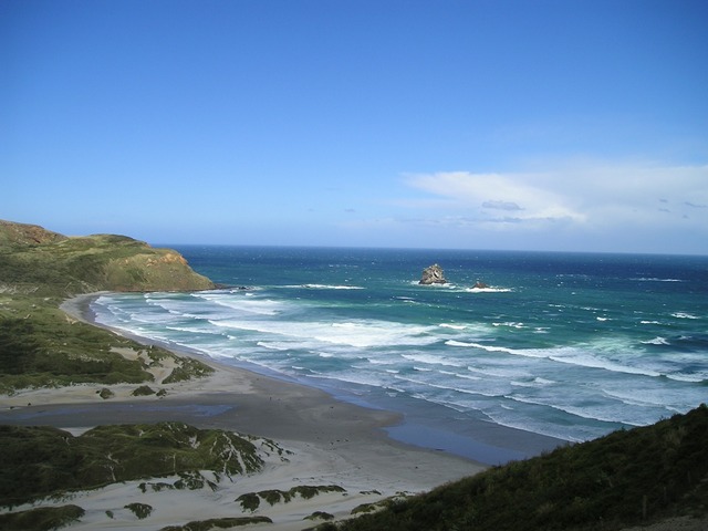
گريت يارموث Great Yarmouth ، كثيراً ما تُعهد للأهالي بإسم يارموث، هي بلدة ساحلية في نورفوك، إنگلترة. وتقع على مصب نهر ير، 20 ميلs (30 kم) شرق نورتش.
وهي منتجع بحري منذ 1760، وهي البوابة من Norfolk Broads إلى بحر الشمال. ولمئات السنين كانت ميناء صيد رئيسي، يعتمد أساساً على صيد الرنجة، إلا حتى صناعة الصيد فيها شهدت انحداراً كبيراً في النصف الثاني من القرن العشرين، وتكاد تكون اختفت الآن. اكتشاف النفط في بحر الشمال في ع1960 أدى إلى ازدهار صناعة تموين منصات النفط، واليوم تقوم المدينة على خدمات منصات الغاز الطبيعي البحرية. More recently, the development of renewable energy sources, especially offshore wind power, has created further opportunities for support services. A wind farm of 30 generators is within sight of the town on the Scroby Sands.
The town has a beach and two piers.
بلدات توأم
گريت يارموث متوأمة مع رامبوييه، فرنسا
الهامش
- ^ Census work day population
- ^ Ordnance Survey (2005). OS Explorer Map OL40 - The Broads. ISBN 0-319-23769-9.
- ^ "Town's last fishing boat fights tide and time". The Daily Telegraph. 14 January 2008.
وصلات خارجية
| مشاع الفهم فيه ميديا متعلقة بموضوع Great Yarmouth. |
- Official website of Great Yarmouth Borough Council
- Great Yarmouth Area Information
نطقب:Norfolk