الجزيرة الشمالية
| الاسم المحلي: Te Ika-a-Māui | |
|---|---|
الجزيرة الشمالية North Island | |
| الجغرافيا | |
| المسقط | Oceania |
| الإحداثيات | |
| أرخبيل | New Zealand |
| المساحة | 113,729 kم2 (43,911 ميل2) |
| ترتيب المساحة | 14th |
| أعلى منسوب | 2٬797 m (9٬177 ft) |
| أعلى نقطة | Mount Ruapehu |
| الإدارة | |
نيوزيلندا | |
| ISO 3166-2:NZ | NZ-N |
| المناطق | 9 |
| Territorial authorities | 43 |
| أكبر مستوطنة | أوكلاند (pop. 1,377,200) |
| الديمغرافيا | |
| التعداد | 3,366,100 (تقدير يونيو2011) |
| الكثافة السكانية | 29٫6 /km2 (76٫7 /sq mi) |
الجزيرة الشمالية North Island، وتُسمى رسمياً أيضاً Te Ika-a-Māui، هي واحدة من الجزيرتين الرئيسيتين في نيوزيلندا، ويفصلها عن الجزيرة الجنوبية الأكبر مساحةً والأقل سكاناً بكثير مضيق كوك. مساحة الجزيرة هي 113,729 كم²، making it the world's 14th-largest island. It has a population of 3,366,100 (تقدير يونيو2011).
Twelve main urban areas (half of them officially cities) are in the North Island. From north to south, they are Whangarei, أوكلاند، Hamilton, Tauranga, Rotorua, Gisborne, New Plymouth, ناپيير، Hastings, Whanganui, Palmerston North، وولنگتون، العاصمة، الواقعة على الطرف الجنوبي الغربي للجزيرة. About 76% of New Zealand's population lives in the North Island.
التسمية والاستخدام
Although the island has been known as the North Island for many years, in 2009 the New Zealand Geographic Board found that, along with the South Island, the North Island had no official name. After a public consultation, the board officially named the island North Island or Te Ika-a-Maui in October 2013.
In prose, the two main islands of New Zealand are called the North Island and the South Island, with the definite articles. It is also normal to use the preposition in rather than on, for example "Hamilton is in the North Island", "my mother lives in the North Island". Maps, headings, tables and adjectival expressions use North Island without the.
أساطير الماوري
According to Māori mythology, the North and South Islands of New Zealand arose through the actions of the demigod Māui. Māui and his brothers were fishing from their canoe (the South Island) when he caught a great fish and pulled it from the sea. While he was not looking his brothers fought over the fish and chopped it up. This great fish became the North Island and thus a Māori name for the North Island is Te Ika-a-Māui ("The Fish of Māui"). The mountains and valleys are believed to have been formed as a result of Māui's brothers' hacking at the fish. Until the early 20th Century, an alternative Māori name for the North Island was Aotearoa. In present usage, Aotearoa is a collective Māori name for New Zealand as a whole.
الاقتصاد
The sub-national GDP of the North Island was estimated at US$102.863 billion in 2003, 79% of New Zealand's national GDP.
فهم البيئة
The North Island is divided into two ecoregions within the temperate broadleaf and mixed forests biome, the northern part being the Northland temperate kauri forest, and the southern part being the North Island temperate forests. The island has an extensive flora and bird population, with numerous National Parks and other protected areas.
المناطق
Nine local government regions cover the North Island and all its adjacent islands and territorial waters.
- Northland
- أوكلاند
- وايكاتو
- Bay of Plenty
- Gisborne
- Taranaki
- Manawatu-Wanganui
- Hawkes Bay
- ولنگتون
المدن والبلدات
The North Island has a larger population than the South Island, with the country's largest city, Auckland, and the capital, Wellington, accounting for nearly half of it.
There are 28 urban areas in the North Island with a population of 10,000 or more:
| الاسم | التعداد (June 2018) |
% من الجزيرة |
|---|---|---|
| أوكلاند | 1,467,800 | 39٫1% |
| Wellington | 215,400 | 5٫7% |
| Hamilton | 169,300 | 4٫5% |
| Tauranga | 135,000 | 3٫6% |
| Lower Hutt | 104,900 | 2٫8% |
| Palmerston North | 80,300 | 2٫1% |
| Napier | 62,800 | 1٫7% |
| Porirua | 55,500 | 1٫5% |
| New Plymouth | 55,300 | 1٫5% |
| Rotorua | 54,500 | 1٫5% |
| Whangarei | 52,600 | 1٫4% |
| Hibiscus Coast | 52,400 | 1٫4% |
| Hastings | 45,000 | 1٫2% |
| Upper Hutt | 41,000 | 1٫1% |
| Whanganui | 39,400 | 1٫1% |
| Gisborne | 35,500 | 0٫9% |
| Paraparaumu | 28,900 | 0٫8% |
| Pukekohe | 24,300 | 0٫6% |
| Taupo | 23,900 | 0٫6% |
| Masterton | 23,900 | 0٫5% |
| Cambridge | 19,150 | 0٫5% |
| Levin | 17,700 | 0٫5% |
| Feilding | 16,450 | 0٫4% |
| Whakatane | 15,850 | 0٫4% |
| Havelock North | 13,950 | 0٫4% |
| Tokoroa | 13,650 | 0٫4% |
| Te Awamutu | 12,400 | 0٫3% |
| Waikanae | 12,100 | 0٫3% |
الديمغرافيا
الثقافة والهوية
| العرق | العدد | % |
|---|---|---|
| أوروپيون | 2,122,587 | 69.6 |
| New Zealand European | 1,934,037 | 63.4 |
| English | 30,393 | 1.0 |
| British | 27,024 | 0.9 |
| South African | 24,921 | 0.8 |
| Dutch | 21,549 | 0.7 |
| European (not further defined) | 20,955 | 0.7 |
| Australian | 16,431 | 0.5 |
| Māori | 514,809 | 16.9 |
| Asian | 418,287 | 13.7 |
| Chinese | 145,089 | 4.8 |
| Indian | 134,559 | 4.4 |
| Filipino | 32,796 | 1.1 |
| Korean | 25,842 | 0.8 |
| Pacific peoples | 274,806 | 9.0 |
| Samoan | 133,968 | 4.4 |
| Cook Islands Maori | 56,910 | 1.9 |
| Tongan | 56,685 | 1.9 |
| Niuean | 22,878 | 0.7 |
| Middle Eastern/Latin American/African | 39,510 | 1.3 |
| Other | 47,394 | 1.6 |
| New Zealander | 45,906 | 1.5 |
| Total people stated | 3,050,874 | 100.0 |
| Not elsewhere included | 186,174 | 5.8 |
الرعاية الصحية
Healthcare in the North Island is provided by fifteen District Health Boards (DHBs). Organised around geographical areas of varying population sizes, they are not coterminous with the Local Government Regions.
| مجلس صحة المقاطعة | المقاطعة | التعداد |
|---|---|---|
| Northland District Health Board (Te Poari Hauora a Rohe o te Tai Tokerau) | Whangarei District, Far North District, Kaipara District | 159,160 |
| Waitemata District Health Board (Te Wai Awhina) | Auckland Region | 525,000 |
| Auckland District Health Board (Te Toka Tumai) | Auckland Region | 468,000 |
| Counties Manukau District Health Board (A Community Partnership) | Auckland Region | 490,610 |
| Waikato District Health Board (Waikato DHB) | Hamilton City, Hauraki District, Matamata-Piako District, Otorohanga District, part of Ruapehu District, South Waikato, Thames-Coromandel District, Waikato District, Waipa District, Waitomo District | 372,865 |
| Bay of Plenty District Health Board (Hauora a Toi) | Tauranga City, Western Bay of Plenty District, Whakatāne District, Kawerau District, Opotiki District | 214,170 |
| Lakes District Health Board (Lakes DHB) | Rotorua District, Taupo District | 102,000 |
| Tairawhiti District Health Board (Te Mana Hauora o te Tairawhiti) | Gisborne District | 44,499 |
| Hawke's Bay District Health Board (Whakawateatia) | Napier City, Hastings District, Wairoa District, Central Hawke's Bay District, Chatham Islands | 155,000 |
| Taranaki District Health Board (Taranaki DHB) | New Plymouth District, Stratford District, South Taranaki District | 104,280 |
| Whanganui District Health Board (Whanganui DHB) | Wanganui District, Rangitikei District, part of Ruapehu District | 62,210 |
| Mid Central District Health Board (Te Pae Hauora o Ruahine o Tararua) | Palmerston North City, Horowhenua District, Manawatu District, Tararua District, part of Kapiti Coast District | 158,838 |
| Wairarapa District Health Board (Te Poari Hauora a Rohe o Wairarapa) | South Wairarapa District, Carterton District, Masterton District | 38,200 |
| Hutt Valley District Health Board (Healthy People) | Lower Hutt City, Upper Hutt City | 145,000 |
| Capital and Coast District Health Board (Upoko ki te Uru Hauora) | Wellington City, Porirua City, part of Kapiti Coast District | 270,000 |
السمات الجغرافية الرئيسية
الخلجان والسمات الساحلية
- Bay of Islands
- Bay of Plenty
- Hauraki Gulf
- Hawke Bay
- Ninety Mile Beach
- North Taranaki Bight
- South Taranaki Bight
البحيرات والأنهار
- Lake Taupo
- Waikato River
- Whanganui River
الرؤوس وأشباه الجزر
- Coromandel Peninsula
- Northland Peninsula
- Cape Palliser
- Cape Reinga
- East Cape
- North Cape
الغابات والمنتزهات الوطنية
- Egmont National Park
- Tongariro National Park
- Waipoua Kauri Forest
- Whanganui National Park
- and many forest parks of New Zealand
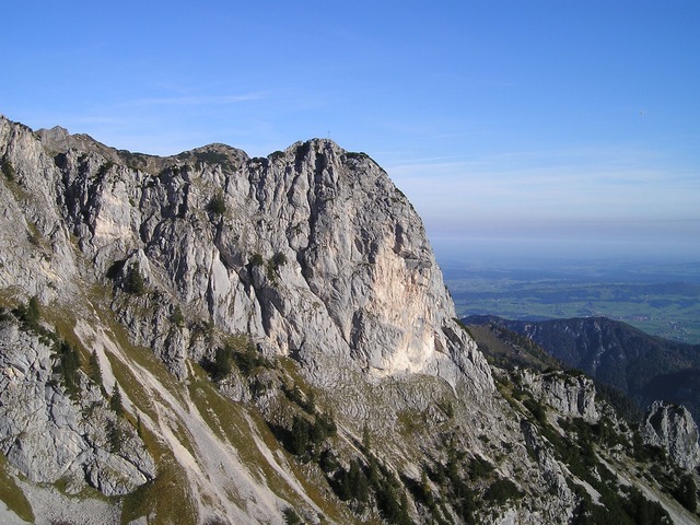
البراكين
- Mount Ruapehu
- Mount Taranaki
- الهضبة البركانية
غيرهم
- كهوف وايتومو
- Taumatawhakatangihangakoauauotamateapokaiwhenuakitanatahu
انظر أيضاً
- قائمة جزر نيوزيلندا
المراجع
- ^ Reporter, Staff (October 10, 2013). "Two official options for NZ island names". The New Zealand Herald. Retrieved December 20, 2018.
- ^ "Quick Facts - Land and Environment : Geography - Physical Features". Statistics New Zealand. 2000. Archived from the original onثمانية April 2013. Retrieved 13 August 2012.
- ^ "Subnational population estimates at 30 June 2011 (boundaries at 1 July 2011)". Statistics New Zealand. 19 December 2011. Retrieved 19 December 2011.
- ^ On some 19th-century maps, the North Island is named New Ulster, which was also a province of New Zealand that included the North Island.
- ^ "The New Zealand Geographic Board Considers North and South Island Names". Land Information New Zealand. 21 April 2009. Retrieved 28 November 2012.
- ^ "Two official options for NZ island names". The New Zealand Herald.عشرة October 2013. Retrieved 10 October 2013.
- ^ "Regional Gross Domestic Product". Statistics New Zealand. 2007. Archived from the original on 20 May 2010. Retrieved 18 February 2010.
- ^ "Subnational Population Estimates: At 30 June 2018 (final)". Statistics New Zealand. 15 November 2018. Retrieved 21 November 2018.
- ^ "Ethnic group (total responses), for the census usually resident population count, 2001, 2006, and 2013 Censuses (RC, TA, AU)". Statistics New Zealand.
وصلات خارجية
-
 Media related to North Island, New Zealand at Wikimedia Commons
-
 [[voy:الجزيرة الشمالية#خطأ لوا في وحدة:Wikidata على السطر 866: attempt to index field 'wikibase' (a nil value).|الجزيرة الشمالية]] travel guide from Wikivoyage
نطقب:Regions of New Zealand
Coordinates: