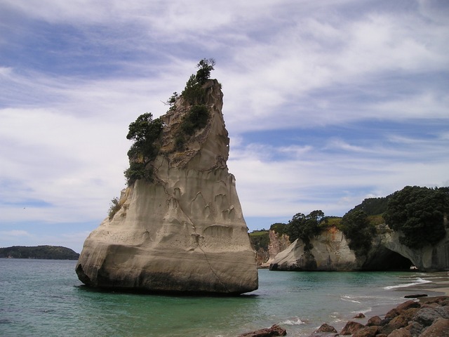
الجزيرة الجنوبية
| الاسم المحلي: Te Waipounamu | |
|---|---|
South Island | |
| الجغرافيا | |
| المسقط | Oceania |
| الإحداثيات | Coordinates: |
| أرخبيل | New Zealand |
| المساحة | 150,437 kم2 (58,084 ميل2) |
| ترتيب المساحة | 12th |
| الطول | 840 km (522 mi) |
| الخط الساحلي | 5٬842 km (3٬630٫1 mi) |
| أعلى منسوب | 3٬724 m (12٬218 ft) |
| أعلى نقطة | Aoraki/Mount Cook |
| الإدارة | |
New Zealand | |
| ISO 3166-2:NZ | NZ-S |
| Regions | 7 |
| Territorial authorities | 23 |
| أكبر مستوطنة | Christchurch (pop. 380,900) |
| الديمغرافيا | |
| Demonym | South Islander, Mainlander |
| التعداد | 1,038,400 (تقدير يونيو2011) |
| الكثافة السكانية | 6٫9 /km2 (17٫9 /sq mi) |
| الجماعات العرقية | European, Māori |
The South Island, also officially named Te Waipounamu, is the larger of the two major islands of New Zealand in surface area; the other being the smaller but more populous North Island. It is bordered to the north by Cook Strait, to the west by the Tasman Sea, and to the south and east by the Pacific Ocean. The South Island covers 150,437 kiloمتر مربعs (1.61929×10¹² قدم2), making it the world's 12th-largest island. It has a temperate climate.
It has a 32 percent larger landmass than the North Island, and as a result is nicknamed the "mainland" of New Zealand, especially by South Island residents, but only 23 percent of New Zealand's 4٫4 million inhabitants live there. In the early stages of European (Pākehā) settlement of the country, the South Island had the majority of the European population and wealth due to the 1860s gold rushes. The North Island population overtook the South in the early 20th century, with 56 percent of the population living in the North in 1911, and the drift north of people and businesses continued throughout the century.
Naming and usage
In the 19th century, some maps named the South Island as Middle Island or New Munster, and the name South Island or New Leinster was used for today's Stewart Island/Rakiura. In 1907 the Minister for Lands gave instructions to the Land and Survey Department that the name Middle Island was not to be used in future. "South Island will be adhered to in all cases".
History
Pre-history
Charcoal drawings can be found on limestone rock shelters in the centre of the South Island, with over 500 sites stretching from Kaikoura to North Otago. The drawings are estimated to be between 500 and 800 years old, and portray animals, people and fantastic creatures, possibly stylised reptiles. Some of the birds pictured are long extinct, including moa and Haast's eagles. They were drawn by early Māori, but by the time Europeans arrived, local Māori did not know the origins of the drawings.
Classical Māori period
Early inhabitants of the South Island were the Waitaha. They were largely absorbed via marriage and conquest by the Kāti Māmoe in the 16th century.[]
الحكم والسياسة
The South Island has no separately represented country subdivision, but is guaranteed 16 of the electorates in the New Zealand House of Representatives. A two-tier structure constituted under the Local Government Act 2002 gives the South Island (and its adjacent islands) seven regional councils for the administration of regional environmental and transport matters and 25 territorial authorities that administer roads, sewerage, building consents, and other local matters. Four of the territorial councils (one city and three districts) also perform the functions of a regional council and are known as unitary authorities.
التقسيمات الإدارية
There are 23 territorial authorities within the South Island: أربعة city councils and 19 district councils. Three territorial authorities (Nelson City Council, and the Tasman and Marlborough District Councils) also perform the functions of a regional council and thus are known as unitary authorities.
| Name | Seat | Area (km2) | Population[1] | Density (per km2) | Region(s) |
|---|---|---|---|---|---|
| Ashburton District | Ashburton | 6٬208 | 30٬100 | 4٫85 | Canterbury |
| Buller District | Westport | 7٬950 | 10٬100 | 1٫27 | West Coast |
| Central Otago District | Alexandra | 9٬966 | 18٬400 | 1٫85 | Otago |
| Christchurch City | Christchurch | 1٬610[2] | 367٬700 | 228٫39 | Canterbury |
| Clutha District | Balclutha | 6٬406 | 17٬550 | 2٫74 | Otago |
| Dunedin City | Dunedin | 3٬340 | 126٬000 | 37٫72 | Otago |
| Gore District | Gore | 1٬251 | 12٬300 | 9٫83 | Southland |
| Grey District | Greymouth | 3٬516 | 13٬900 | 3٫95 | West Coast |
| Hurunui District | Amberley | 8٬661 | 11٬300 | 1٫30 | Canterbury |
| Invercargill City | Invercargill | 491 | 53٬000 | 107٫94 | Southland |
| Kaikoura District | Kaikoura | 2٬050 | 3٬860 | 1٫88 | Canterbury |
| Mackenzie District | Fairlie | 7٬442 | 4٬050 | 0٫54 | Canterbury |
| Marlborough District | Blenheim | 12٬484 | 45٬600 | 3٫65 | unitary authority |
| Nelson City | Nelson | 445 | 46٬200 | 103٫82 | unitary authority |
| Queenstown-Lakes District | Queenstown | 9٬368 | 28٬700 | 3٫06 | Otago |
| Selwyn District | Rolleston | 6٬557 | 41٬100 | 6٫27 | Canterbury |
| Southland District | Invercargill | 32٬605[3] | 29٬600 | 0٫91 | Southland |
| Tasman District | Richmond | 9٬786 | 48٬100 | 4٫92 | unitary authority |
| Timaru District | Timaru | 2٬726 | 44٬700 | 16٫40 | Canterbury |
| Waimakariri District | Rangiora | 2٬216 | 48٬600 | 21٫93 | Canterbury |
| Waimate District | Waimate | 3٬577 | 7٬630 | 2٫13 | Canterbury |
| Waitaki District | Oamaru | 7٬212 | 20٬900 | 2٫90 |
Canterbury (59.61%) Otago (40.39%) |
| Westland District | Hokitika | 11٬870 | 8٬960 | 0٫75 | West Coast |
- Population as of تقدير يونيو2011.
- Total of Christchurch City and Banks Peninsula areas.
- Includes Stewart Island and Solander Islands.
الأحزاب
This is a list of political parties, past and present, who have their headquarters in the South Island.
- Aotearoa Legalise Cannabis Party
- Imperial British Conservative Party
- National Democrats Party
- New Munster Party
- New Zealand Democratic Party
- New Zealand Progressive Party
- South Island Party
إنفاذ القانون
الشرطة
السكان
Compared to the more populated and multi-ethnic North Island, the South Island has a smaller, more homogeneous resident population of 1,038,400 (تقدير يونيو2011). According to the Statistics New Zealand Subnational Population Projections: 2006–2031; the South Island's population will increase by an average of 0.6 percent a year to 1,047,100 in 2011, 1,080,900 in 2016, 1,107,900 in 2021, 1,130,900 in 2026 and 1,149,400 in 2031.
At the 2013 Census of Population and Dwellings, 88.2 percent of South Islanders identified as of European ethnicity, 8.7 percent as Māori, 5.6 percent as Asian, 2.2 percent as Pacific Peoples, 0.8 percent as Middle Eastern/Latin American/African, and 2.1 percent as another ethnicity (mainly 'New Zealander').
Eighteen percent of the South Island's population was born overseas, compared to 27.5 percent in the North Island. The British Isles is the largest region of origin, accounting for 37.9 percent of the overseas-born population in the South Island.
Around 48.6 percent of South Islanders affiliate with Christianity and 3.1 percent affiliate with non-Christian religions, while 45.8 percent are irreligious. Anglicanism is the largest Christian denomination in the South Island with 12.7 percent affiliating, closely followed by Catholicism at 12.1 percent and Presbyterianism at 11.7 percent.
Urbanisation
There are 14 urban areas in the South Island with a population of 10,000 or more:
| Name | Population (June 2018) |
% of island |
|---|---|---|
| Christchurch | 377,200 | 33٫2% |
| Dunedin | 104,500 | 9٫2% |
| Nelson | 49,300 | 4٫3% |
| Invercargill | 48,700 | 4٫3% |
| Timaru | 28,300 | 2٫5% |
| Blenheim | 26,400 | 2٫3% |
| Ashburton | 19,600 | 1٫7% |
| Rangiora | 18,400 | 1٫6% |
| Rolleston | 16,350 | 1٫4% |
| Queenstown | 15,650 | 1٫4% |
| Richmond | 15,000 | 1٫3% |
| Mosgiel | 13,400 | 1٫2% |
| Oamaru | 13,150 | 1٫2% |
| Kaiapoi | 11,850 | 1�0% |
Economy
The South Island economy is strongly focused on tourism and primary industries like agriculture. The other main industry groups are manufacturing, mining, construction, energy supply, education, health and community services.
The sub-national GDP of the South Island was estimated at NZ$61.5 billion in 2017, 22.7% of New Zealand's national GDP.
الطاقة
The South Island is a major centre for electricity generation, especially in the southern half of the island and especially from hydroelectricity. In 2010, the island generated 18,010 GWh of electricity, 41.5% of New Zealand's total electricity generation. Nearly all (98.7%) of the island's electricity is generated by hydroelectricity, with most of the remainder coming from wind generation.
The three large hydro schemes in the South Island: Waitaki, Clutha, and Manapouri, together produce nearly 92% of the island's electricity. The Waitaki River is the largest at 1738 MW of installed capacity. The Waitaki River is the largest hydroelectric scheme, consisting of nine powerhouses commissioned between 1936 and 1985, and generating about 7600 GWh annually, around 18% of New Zealand's electricity generation and more than 30% of all its hydroelectricity. The Clutha River has two major stations generating electricity: Clyde Dam (432 MW, commissioned 1992) and Roxburgh Dam (360 MW, commissioned 1962). Manapouri Power Station is an isolated station located in Southland, generating 730 MW of electricity and producing 4800 GWh annually - the largest single hydroelectric power station in the country.
The Great South Basin off the coast of Otago and Southland at over 500,000 km2 (covering an area 1.5 times New Zealand's land mass) is one of New Zealand's largest undeveloped offshore petroleum basins with prospects for both oil and gas. In July 2007 the New Zealand Government awarded oil and gas exploration permits for four areas of the Great South Basin, situated in the volatile waters off the Southern Coast of New Zealand. The three successful permit holders are:
- a consortium led by ExxonMobil New Zealand (Exploration) Limited (United States) which includes local company Todd Exploration Limited (New Zealand);
- a consortium led by OMV New Zealand Limited (Austria) which includes PTTEP Offshore Investment Company Ltd (تايلند), Mitsui Exploration and Production Australia Pty Ltd (Japan); and
- Greymouth Petroleum Limited (New Zealand)
الجغرافيا
انظر أيضاً
- Cities and towns of the South Island by population
- List of twin towns and sister cities in the South Island
- Military of the South Island
- New Munster
- Nor'west arch
- South Island nationalism
المراجع
- ^ Reporter, Staff (10 October 2013). "Two official options for NZ island names". The New Zealand Herald. Retrieved 20 December 2018.
- ^ "Quick Facts - Land and Environment : Geography - Physical Features". Statistics New Zealand. 2000. Archived from the original onثمانية April 2013. Retrieved 13 August 2012.
- ^ King, Michael (2003). The Penguin History of New Zealand. Auckland: Penguin Books. pp. 280–281. ISBN .
- ^ "The Waitara Harbour Bill". Taranaki Herald. 30 July 1907. p. 4.
- ^ "Very Old Maori Rock Drawings". Natural Heritage Collection. Archived from the original on 24 February 2009. Retrieved 15 February 2009.
- ^ "The SRARNZ Logo". Society for Research on Amphibians and Reptiles in New Zealand. Retrieved 15 February 2009. []
- ^ Keith, Hamish (2007). The Big Picture: A history of New Zealand art from. 1642. pp. 11–16. ISBN .
- ^ Living Density: Table 1 Archived 28 November 2007 at the Wayback Machine., Housing Statistics, Statistics New Zealand. Retrieved 25 January 2009. Areas are based on 2001 boundaries. Water bodies greater than 15 hectares are excluded.
- ^ "Subnational population estimates at 30 June 2011 (boundaries at 1 July 2011)". Statistics New Zealand. 19 December 2011. Retrieved 19 December 2011.
- ^ "Archived copy". Archived from the original on 1 March 2010. Retrieved 25 February 2010. CS1 maint: archived copy as title (link)
- ^ "2013 Census QuickStats about culture and identity – data tables". Statistics New Zealand. 15 April 2014. Archived from the original on 24 May 2014. Retrieved 25 January 2016. Note some percentages (e.g. ethnicity, language) may add to more than 100 percent as people could give multiple responses.
- ^ "Subnational Population Estimates: At 30 June 2018 (final)". Statistics New Zealand. 15 November 2018. Retrieved 21 November 2018.
- ^ "Regional gross domestic product: Year ended March 2017 - Stats NZ". www.stats.govt.nz.
- ^ "Energy Data File". Ministry of Economic Development. 13 July 2011.
- ^ "MED Energy Sector Information: Waitaki River". MED. Retrieved 24 December 2008.
- ^ "Home > Projects > Aviemore Dam". URS Corp. Retrieved 15 January 2009.
- ^ "Southland Energy Consortium". Energy.southlandnz.com. Archived from the original on 16 July 2011. Retrieved 2 August 2010.
Further reading
- Atkinson, Brett, et al. New Zealand's South Island (2010) excerpt and text search
- Bull, Mary P. (2004). . Trafford Publishing.
External links
| مشاع الفهم فيه ميديا متعلقة بموضوع South Island, New Zealand. |
| Wikivoyage has a travel guide for الجزيرة الجنوبية. |
- South Island
- South Island Road Map
نطقب:Regions of New Zealand