مقاطعة گرينزڤل، ڤرجينيا
Greensville County | ||
|---|---|---|
U.S. county | ||
|
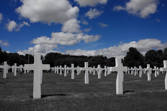
Greensville County Courthouse, also serving the City of Emporia
| ||
| ||
|
Location within the U.S. state of Virginia
| ||
|
مسقط Virginia ضمن الولايات المتحدة | ||
| الإحداثيات: خطأ لوا في وحدة:Coordinates على السطر 611: attempt to index field 'wikibase' (a nil value). | ||
| البلد | ||
| State |
|
|
| تأسست | 1780 | |
| Seat | Emporia | |
| Largest town | Jarratt | |
| المساحة | ||
| • الإجمالية | 297 ميل² (770 كم²) | |
| • البر | 295 ميل² (760 كم²) | |
| • الماء | 1٫6 ميل² (4 كم²) 0.5%% | |
| التعداد(2010) | ||
| • الإجمالي | 12٬243 | |
| • الكثافة | 40/sq mi (15/km2) | |
| منطقة التوقيت | Eastern (التوقيت العالمي المنسق−5) | |
| • الصيفي | EDT (UTC−4) | |
| Congressional district | 4th | |
| المسقط الإلكتروني | greensvillecountyva.gov | |
مقاطعة گرينزڤل بالإنگليزية: Greensville County هي إحدى المقاطعات في ولاية ڤرجينيا في الولايات المتحدة الأمريكية.
المقاطعات / المدن المستقلة المجاورة
- Brunswick County, Virginia - غرب
- Dinwiddie County, Virginia - شمال
- Sussex County, Virginia - northeast
- Southampton County, Virginia - شرق
- Northampton County, North Carolina - جنوب
- Emporia, Virginia - surrounded by Greensville County
الطرق الرئيسية
-
 I‑95
I‑95
- US 58
-
 US 301
- SR 139
- SR 186
الديمغرافيا
| التعداد التاريخي | |||
|---|---|---|---|
| التعداد | Pop. | %± | |
| 1790 | 6٬362 | — | |
| 1800 | 6٬727 | 5٫7% | |
| 1810 | 6٬853 | 1٫9% | |
| 1820 | 6٬858 | 0٫1% | |
| 1830 | 7٬117 | 3٫8% | |
| 1840 | 6٬366 | −10٫6% | |
| 1850 | 5٬639 | −11٫4% | |
| 1860 | 6٬374 | 13�0% | |
| 1870 | 6٬362 | −0٫2% | |
| 1880 | 8٬407 | 32٫1% | |
| 1890 | 8٬230 | −2٫1% | |
| 1900 | 9٬758 | 18٫6% | |
| 1910 | 11٬890 | 21٫8% | |
| 1920 | 11٬606 | −2٫4% | |
| 1930 | 13٬388 | 15٫4% | |
| 1940 | 14٬866 | 11�0% | |
| 1950 | 16٬319 | 9٫8% | |
| 1960 | 16٬155 | −1�0% | |
| 1970 | 9٬604 | −40٫6% | |
| 1980 | 10٬903 | 13٫5% | |
| 1990 | 8٬853 | −18٫8% | |
| 2000 | 11٬560 | 30٫6% | |
| 2010 | 12٬243 | 5٫9% | |
| تقدير 2014 | 11٬681 | −4٫6% | |
| U.S. Decennial Census 1790-1960 1900-1990 1990-2000 2010-2012 | |||
انظر أيضاً
- National Register of Historic Places in Greensville County, Virginia
الهامش
- ^ "Annual Estimates of the Resident Population for Incorporated Places: April 1, 2010 to July 1, 2014". Retrieved June 4, 2015.
- ^ "U.S. Decennial Census". United States Census Bureau. Retrieved January 2, 2014.
- ^ "Historical Census Browser". University of Virginia Library. Retrieved January 2, 2014.
- ^ "Population of Counties by Decennial Census: 1900 to 1990". United States Census Bureau. Retrieved January 2, 2014.
- ^ "Census 2000 PHC-T-4. Ranking Tables for Counties: 1990 and 2000" (PDF). United States Census Bureau. Retrieved January 2, 2014.
-
^ خطأ استشهاد: وسم
<ref>غير سليم؛ لا نص تم توفيره للمراجع المسماةQF
وصلات خارجية
- Official website
نطقب:Greensville County, Virginia
Coordinates: