الغرب (البرتغال)
| Algarve | |
| Distrito de Faro | |
| Region | |
|
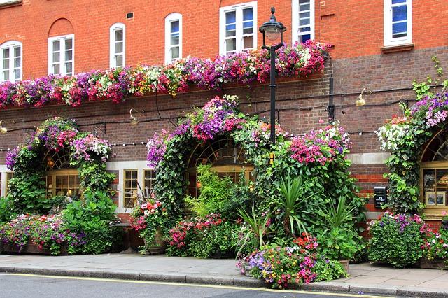
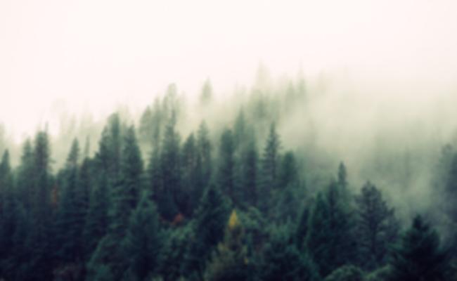
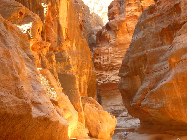
Algarve's typical coast (Marinha Beach, near Lagoa).
| |
| البلد | Portugal |
|---|---|
| المنطقة | Algarve |
| العاصمة | Faro |
| - الارتفاع | 11 م (36 قدم) |
| أعلى نقطة | Fóia |
| - المنسوب | 902.0 م (2,959 قدم) |
| أوطى نقطة | Sea level |
| - المسقط | Atlantic Ocean |
| - المنسوب | 0.0 م (0 قدم) |
| المساحة | 4,996.80 kم2 (1,929 ميل2) |
| التعداد | 451٬006 (2011) |
| الكثافة | 90/كم2 (233/ميل2) |
| Timezone | WET (UTC+0) |
| - summer (DST) | WEST (UTC+1) |
| NUTS | PT15 |
| GDP (PPP) | 2013 estimate |
| – Total | €9.274 billion |
| – Per capita | €20,900 |
| GDP (nominal) | 2013 estimate |
| – Total | €7.232 billion |
| – Per capita | €16,300 |
|
Location of the Algarve Region in context of the national borders
| |
| Wikimedia Commons: Algarve | |
| المسقط: amal.pt | |
| Statistics from INE (2005); geographic detail from Instituto Geográfico Português (2010) | |
الغرب (Algarve ؛ بالإنگليزية //؛ البرتغالية: [aɫˈɡaɾvɨ]، من العربية: الغرب) هي المنطقة الأقصى جنوباً في البرتغال القارية. وتبلغ مساحتها 4,997 كم² ويعيش فيها 451,006 نسمة، وتضم 16 بلدية. المركز الاداري للمنطقة هوفارو، حيث يوجد جميع من من المطار الدولي (FAO) والجامعة العامة، جامعة الغرب. Tourism and related activities are extensive and make up the bulk of the Algarve's summer economy. Production of food, which includes fish and other seafood, different types of fruit such as oranges, figs, plums, carob beans, and almonds, is also economically important in the region. Although Lisbon surpasses the Algarve in terms of tourism revenue, the Algarve is still, overall, considered to be the biggest and most important Portuguese tourist region, having received an estimated total of 7.1 million tourists in 2017. Its population triples in the peak holiday season due to seasonal residents. The Algarve is also increasingly being sought after, mostly by central and northern Europeans, as a permanent place to settle. An American-based study concluded that the Algarve was the world's best place to retire.
The Algarve is one of the most developed regions of Portugal, and with a GDP per capita at 86% of the European Union average, the third-richest (behind Lisbon and Madeira).
التاريخ
Human presence in southern Portugal dates back to the Paleolithic and Neolithic periods. The presence of megalithic stones in the area of Vila do Bispo attests to this presence.
الجغرافيا
تغطي منطقة الغرب 4,997 كم²، extending just south of the Tagus valley to the southern coast of the Iberian Peninsula. Its highest point is Fóia, 902 م (2,959 قدم), in the mountain range of Monchique. It also includes some islands and islets. The region is also the home of the Ria Formosa Lagoon, a nature reserve of over 170 km2 and a stopping place for hundreds of different species of birds. The length of the south-facing coastline is roughly 155 km. Beyond the westernmost point of Cape St. Vincent it stretches a further 50 km to the north. The coastline is notable for picturesque limestone caves and grottoes, particularly around Lagos, which are accessible by powerboat.
المناخ
The maximum recorded temperatures in the Algarve fluctuate between 25 °م (77 °ف) in winter and 48 °م (118 °ف) in summer, with the temperature rarely falling below zero in the winter. The winter of 2008–09 was exceptionally cold and wet. Temperatures below 0 °م (32 °ف) were recorded in coastal areas for the first time in many years.
| بيانات مناخ فارو | |||||||||||||
|---|---|---|---|---|---|---|---|---|---|---|---|---|---|
| الشهر | يناير | فبراير | مارس | أبريل | مايو | يونيو | يوليو | أغسطس | سبتمبر | اكتوبر | نوفمبر | ديسمبر | العام |
| العظمى القياسية °س (°ف) | 21.9 (71.4) |
24.7 (76.5) |
28.9 (84) |
30.1 (86.2) |
33.6 (92.5) |
37.1 (98.8) |
44.3 (111.7) |
39.6 (103.3) |
37.4 (99.3) |
33.3 (91.9) |
28.6 (83.5) |
24.0 (75.2) |
44٫3 (111٫7) |
| العظمى المتوسطة °س (°ف) | 16.1 (61) |
16.9 (62.4) |
19.1 (66.4) |
20.4 (68.7) |
22.8 (73) |
26.4 (79.5) |
29.2 (84.6) |
28.8 (83.8) |
26.6 (79.9) |
23.2 (73.8) |
19.6 (67.3) |
17.0 (62.6) |
22٫2 (72) |
| المتوسط اليومي °س (°ف) | 12.0 (53.6) |
12.8 (55) |
14.8 (58.6) |
16.1 (61) |
18.4 (65.1) |
21.9 (71.4) |
24.2 (75.6) |
24.1 (75.4) |
22.3 (72.1) |
19.3 (66.7) |
15.7 (60.3) |
13.3 (55.9) |
17٫9 (64٫2) |
| الصغرى المتوسطة °س (°ف) | 7.9 (46.2) |
8.7 (47.7) |
10.5 (50.9) |
11.8 (53.2) |
14.0 (57.2) |
17.3 (63.1) |
19.1 (66.4) |
19.4 (66.9) |
18.0 (64.4) |
15.3 (59.5) |
11.7 (53.1) |
9.6 (49.3) |
13٫6 (56٫5) |
| الصغرى القياسية °س (°ف) | -1.2 (29.8) |
-1.2 (29.8) |
2.3 (36.1) |
3.6 (38.5) |
6.7 (44.1) |
8.0 (46.4) |
11.9 (53.4) |
13.1 (55.6) |
9.9 (49.8) |
7.8 (46) |
2.7 (36.9) |
1.2 (34.2) |
-1٫2 (29٫8) |
| هطول mm (inches) | 59.3 (2.335) |
52.0 (2.047) |
39.4 (1.551) |
38.6 (1.52) |
21.7 (0.854) |
4.3 (0.169) |
1.8 (0.071) |
3.9 (0.154) |
23.2 (0.913) |
60.1 (2.366) |
90.4 (3.559) |
114.1 (4.492) |
508٫8 (20٫031) |
| Avg. precipitation days (≥ 0.1 mm) | 12 | 13 | 9 | 10 | 7 | 4 | 1 | 1 | 3 | 9 | 10 | 11 | 90 |
| Sunshine hours | 170.5 | 165.2 | 232.5 | 252.0 | 313.1 | 333.0 | 368.9 | 353.4 | 273.0 | 226.3 | 183.0 | 167.4 | 3٬038٫3 |
| Source: Instituto de Meteorologia,World Meteorological Organization(precipitation days), Hong Kong Observatory(sunshine hours) | |||||||||||||
| البلدية | التعداد (2011) | المساحة (كم²) |
|---|---|---|
| Albufeira | 40,828 | 140.66 |
| Alcoutim | 2,917 | 575.36 |
| الجذور | 5,884 | 323.50 |
| كاستروماريم | 6,747 | 300.84 |
| فارو | 64,560 | 202.57 |
| لاگوا | 22,975 | 88.25 |
| لاگوس | 31,049 | 212.99 |
| Loulé | 70,622 | 763.67 |
| Monchique | 6,045 | 395.30 |
| Olhão | 45,396 | 130.86 |
| Portimão | 55,614 | 182.06 |
| São Brás de Alportel | 10,662 | 153.37 |
| شلب | 37,126 | 680.06 |
| تاڤيرا | 26,167 | 606.97 |
| Vila do Bispo | 5,258 | 179.06 |
| Vila Real de Santo António | 19,156 | 61.25 |
| الإجمالي | 451,006 | 4996.80 |
الاقتصاد
Agricultural products of the region تضم التين واللوز والبرتنطق وcarob bean, شجرة الفراولة وبلوط الفلين.
الثقافة
The Algarve is famous for its pottery and ceramics, particularly hand-painted pottery and azulejos, which are painted, tin-glazed ceramic tiles.
معرض صور
The city of Tavira capital of the Costa do Acantilado
The historic centre of Lagos
Portimão at night
A street in Silves
Partial view of Carvoeiro
A beach in Albufeira
The city of Vila Real de Santo António
Marina beach in Vilamoura
Typical view of the Algarve coast
Beach in Quarteira
Shepherd and sheep near Lagos
Desert island near Faro
Sagres Point, in the extreme of continental Portugal
Loulé's municipal market
The bog fountain in Alte
Silves Cathedral
The open fields of the Algarve in spring
The spa resort town of Caldas de Monchique
انظر أيضاً
- غرب الأندلس
- مملكة الغرب
- Algarve VR
الهامش
- ^ "EU Regions". Eurostat.
- ^ "Regiões de Portugal". AICEP. Archived from the original on 22 February 2014.
- ^ Direção-Geral do Território[]
- ^ "Statistics Portugal". ine.pt.
-
^ خطأ استشهاد: وسم
<ref>غير سليم؛ لا نص تم توفيره للمراجع المسماةlaw75 - ^ "Lisboa ultrapassa pela primeira vez 1.000 milhões de euros em receitas de alojamento turístico" (Economy). O Jornal Económico. Retrieved 26 February 2018.
- ^ "Algarve com 4,2 milhões de turistas e 20 milhões de dormidas oficiais em 2017 - AHETA" (Economy). Diário de notícias. Retrieved 26 February 2018.
- ^ "Algarve once again elected best place in the world to retire". The Portugal News.
- ^ GDP per inhabitant ranged from 28% of the EU27 average in Severozapaden in Bulgaria to 343% in Inner London
- ^ Faro – Instituto de Meteorologia, 1981–2010 (provisórias)
- ^ "Monthly Averages for Faro, Portugal". World Meteorological Organization. Retrieved 5 September 2012.
- ^ "Climatological Information for Faro, Portugal" Hong Kong Observatory. Retrievedخمسة September 2012
وصلات خارجية
- Associação de Turismo do Algarve
- Film Production Algarve