كولورادوسپرنگز، كولورادو
City of Colorado Springs | ||
|---|---|---|
City | ||
|
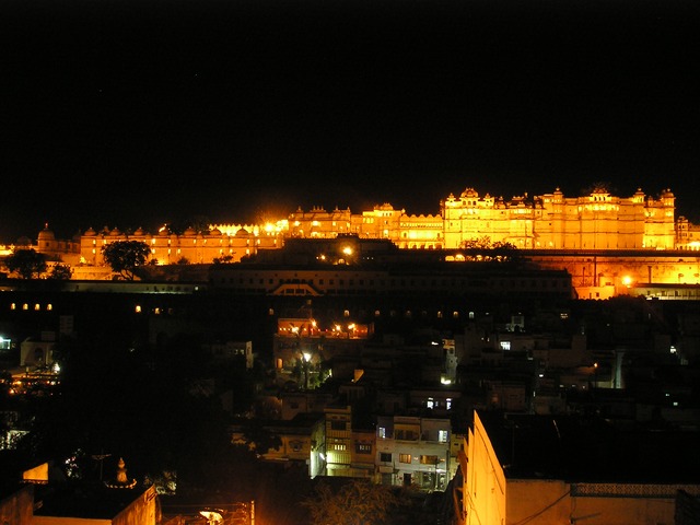
Colorado Springs with Front Range in background
| ||
| ||
| Nickname(s): The Springs
| ||
|
Location in El Paso County and the State of Colorado
| ||
| Country |
|
|
| State |
|
|
| County | El Paso County seat | |
| Incorporated | June 19, 1886 | |
| الحكم | ||
| • النوع | Home Rule Municipality | |
| • Mayor | Lionel Rivera (R) | |
| المساحة | ||
| • City | 186٫1 ميل² (482٫1 كم²) | |
| • البر | 185٫7 ميل² (481٫1 كم²) | |
| • الماء | 0٫4 ميل² (1٫0 كم²) | |
| الارتفاع | 6٬035-7٬200 ft (1٬832 m) | |
| التعداد(2008) | ||
| • City | 380٬307 | |
| • الكثافة | 1٬942٫9/sq mi (767٫25/km2) | |
| • العمرانية | 617٬714 | |
| منطقة التوقيت | MST (التوقيت العالمي المنسق-7) | |
| • الصيفي | MDT (UTC-6) | |
| ZIP codes | 80901-80951, 80960, 80962, 80970, 80977, 80995, 80997, 80919, 80907 | |
| مفتاح الهاتف | 719 | |
| FIPS code | 08-16000 | |
| GNIS feature ID | 0204797 | |
| Highways | I-25, US 24, US 85, SH 29, SH 83, SH 94, SH 115 | |
| المسقط الإلكتروني | City of Colorado Springs | |
|
Second most populous Colorado city
image seal = | ||
مسقط كولورادوسبرينغس في ولاية كولورادو
كولورادوسپرنگز (Colorado Springs) مدينة تقع في الوسط الشرقي من ولاية كولورادوالأمريكية في مقاطعة إل باسوعلى الحافة الشرقية لجبال الروكي الجنوبية. وهي مدينة سياحية، وتحتوي على أكاديمية القوات الجوية الأمريكية التي تأسست في عام 1958. عدد سكانها 370000 نسمة مما يجعلها ثاني أكبر مدن كولورادومن حيث عدد السكان، وترتيبها على مستوى مدن الولايات المتحدة ككل هو49. ترتفع المدن لحوالي ميل واحد فوق مستوى سطح البحر. تأسست المدينة في عام 1871، وسميت بعد مدة باسمها الحالي الذي يعني "ينابيع كولورادو" لأنه تقع بالقرب من الينابيع. تبعد المدينة بحوالي 68 ميلاً جنوب مدينة دنفر (عاصمة كولورادو).
التاريخ
Statue of General William Palmer in front of Palmer High School.
The Pioneers Museum (old court house) contains displays of the city's founding and history.
الجغرافيا
Pikes Peak, the Eastern-most 14er in the United States.
المناخ
| متوسطات الطقس لColorado Springs, CO, USA | |||||||||||||
|---|---|---|---|---|---|---|---|---|---|---|---|---|---|
| شهر | يناير | فبراير | مارس | أبريل | مايو | يونيو | يوليو | أغسطس | سبتمبر | اكتوبر | نوفمبر | ديسمبر | السنة |
| العظمى القياسية °F (°C) | 73 (23) | 76 (24) | 81 (27) | 87 (31) | 95 (35) | 100 (38) | 102 (39) | 101 (38) | 94 (34) | 86 (30) | 78 (26) | 77 (25) | 102 (39) |
| متوسط العظمى °ف (°م) | 41 (5) | 45 (7) | 50 (10) | 59 (15) | 68 (20) | 79 (26) | 84 (29) | 81 (27) | 73 (23) | 63 (17) | 50 (10) | 42 (6) | 62 (17) |
| متوسط الصغرى °ف (°م) | 14 (-10) | 18 (-8) | 24 (-4) | 31 (-1) | 41 (5) | 50 (10) | 55 (13) | 54 (12) | 45 (7) | 34 (1) | 23 (-5) | 16 (-9) | 34 (1) |
| الصغرى القياسية °ف (°C) | -32 (-36) | -27 (-33) | -11 (-24) | -3 (-19) | 21 (-6) | 32 (0) | 42 (6) | 39 (4) | 22 (-6) | 5 (-15) | -11 (-24) | -27 (-33) | -32 (-36) |
| هطول الأمطار بوصة (mm) | 0.28 (7.1) | 0.35 (8.9) | 1.06 (26.9) | 1.62 (41.1) | 2.39 (60.7) | 2.34 (59.4) | 2.85 (72.4) | 3.48 (88.4) | 1.23 (31.2) | 0.86 (21.8) | 0.52 (13.2) | 0.42 (10.7) | 17٫40 (442) |
| المصدر: The Weather Channel September 2008 | |||||||||||||
الديموغرافيا
| التعداد تاريخياً | |||
|---|---|---|---|
| الإحصاء | التعداد | %± | |
| 1870 | 1٬480 | ||
| 1880 | 4٬226 | 185.5% | |
| 1890 | 11٬140 | 163.6% | |
| 1900 | 21٬085 | 89.3% | |
| 1910 | 29٬078 | 37.9% | |
| 1920 | 30٬105 | 3.5% | |
| 1930 | 33٬237 | 10.4% | |
| 1940 | 36٬789 | 10.7% | |
| 1950 | 45٬472 | 23.6% | |
| 1960 | 70٬194 | 54.4% | |
| 1970 | 135٬060 | 92.4% | |
| 1980 | 214٬914 | 59.1% | |
| 1990 | 281٬140 | 30.8% | |
| 2000 | 360٬890 | 28.4% | |
| تقديري 2008 | 380٬307 | 5.4% | |
| source: | |||
الحكومة
City Hall.
الاقتصاد
المنشآت العسكرية
AFSPC Headquarters, Peterson AFB, Colorado Springs.
Cadets in front of the Academy Chapel
السياحة
Garden of the Gods
الرياضة
The United States Olympic Committee headquarters and training facility.
المؤسسات الدينية
Focus on the Family Visitors Center
النقل
- US 24 traverses through eastern Colorado from Limon through several towns such as Matheson, Simla, Ramah, Calhan, Peyton and Falcon until it reaches the city and leaves the city through the mountains on its way to Minturn, CO.
- SH 83 runs north-south from Denver to Colorado Springs.
- SH 115 begins from the US 50 interchange in Cañon City to US 85 (Nevada Avenue) in the city.
- US 85 US 85 enters the city at Fountain and is signed as Nevada Avenue until it leaves the city at exit 148.
- US 87 US 87 remains concurrent with I-25 throughout Colorado.
A Metro bus navigates past a parking garage in downtown.
الاعلام
التعليم
Doolittle Hall on the campus of the United States Air Force Academy.
المدن الشقيقة
Sister cities of Colorado Springs include:
- Fujiyoshida, Japan (1962)
- Kaohsiung, Taiwan (1983)
- Smolensk, Russia (1993)
- Bishkek, Kyrgyzstan (1994)
- Nuevo Casas Grandes, Mexico (1996)
- Bankstown, Australia (1999)
انظر أيضا
- Colorado municipalities
- Pikes Peak Library District
- South Central Colorado Urban Area
- Citadel Mall
- Marketplace At Austin Bluffs
المصادر
- ^ "Active Colorado Municipalities". State of Colorado, Department of Local Affairs. Retrieved 2007-09-01.
- ^ "Colorado Municipal Incorporations". State of Colorado, Department of Personnel & Administration, Colorado State Archives. 2004-12-01. Retrieved 2007-09-02.
- ^ U.S. Census Bureau (2009). "Incorporated Places and Minor Civil Divisions: Coorado" (CSV). 2008 Population Estimates. Retrieved 2009-09-21.
- ^ "ZIP Code Lookup" (JavaScript/HTML). United States Postal Service. Retrieved September 7, 2007.
-
^ "Annual Estimates of the Population for Incorporated Places over 100,000" (CSV). 2007 Population Estimates. U.S. Census Bureau, Population Division. November 18, 2007. Retrieved November 18 2008. Unknown parameter
|dateformat=ignored (help); Check date values in:|accessdate=(help) - ^ "Monthly Averages for Colorado Springs, CO". The Weather Channel. 2008. Retrieved 2008-09-19.
- ^ Moffatt, Riley. Population History of Western U.S. Cities & Towns, 1850-1990. Lanham: Scarecrow, 1996, 68.
وصلات خارجية
| مشاع الفهم فيه ميديا متعلقة بموضوع Colorado Springs, Colorado. |
- City of Colorado Springs website
- Colorado Springs Fine Arts Center
- Official Site of the Colorado Springs Convention & Visitors Bureau
- Early Capitol and Legislative Assembly Locations
- Colorado City Historical Society
- 1905 Magazine Article with historical photos
نطقب:El Paso County, Colorado
نطقب:CO cities and mayors of 100,000 population