هارِسبرگ، پنسلڤانيا
|
هارِسبرگ، پنسلڤانيا
Harrisburg, Pennsylvania
هارِسبرگ
| ||
|---|---|---|
عاصمة الولاية | ||
| مدينة هارِسبرگ | ||
|
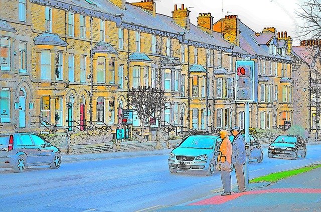
من أعلى لأسفل، ومن اليسار لليمين: خط أفق هارِسبرگ؛ Market Square in Downtown Harrisburg; Pennsylvania State Capitol; FNB Field; Walnut Street Bridge; نهر سسكويهانا
| ||
| ||
| Nickname(s): "عاصمة پنسلڤانيا".
| ||
| الشعار الحادي: "En la rou Justita"
| ||
|
المسقط في مقاطعة دوفن في ولاية پنسلڤانيا
| ||
|
هارِسبرگ، پنسلڤانيا | ||
| الإحداثيات: | ||
| البلد | الولايات المتحدة | |
| ولاية | پنسلڤانيا | |
| المقاطعة | دوفن | |
| European settlement | About 1719 | |
| Incorporated | 1791 | |
| Charter | March 19, 1860 | |
| أسسها | John Harris, Sr. | |
| السَمِيْ | John Harris, Sr. | |
| الحكم | ||
| • النوع | Mayor-Council | |
| • العمدة | Eric Papenfuse (D) | |
| • City Controller | Charlie DeBrunner (D) | |
| • City Council | Council Members
|
|
| • State Senate | Rob Teplitz (D) | |
| • State Representative | Patty Kim (D) | |
| المساحة | ||
| • مدينة | 11٫4 ميل² (26٫9 كم²) | |
| • البر | 8٫1 ميل² (21٫0 كم²) | |
| • الماء | 3٫3 ميل² (8٫6 كم²) | |
| • الحضر | 335٫4 ميل² (539٫7 كم²) | |
| الارتفاع | 320 ft (98 m) | |
| التعداد(2010) | ||
| • مدينة | 49٬528 | |
| • الكثافة | 6٬114/sq mi (2٬361/km2) | |
| • الحضر | 444٬474 (86th) | |
| • العمرانية | 560٬849 (95) | |
| • CSA | 1٬219٬422(43rd) | |
| صفة المواطن | Harrisburgian | |
| منطقة التوقيت | EST (التوقيت العالمي المنسق-5) | |
| • الصيفي | EDT (UTC-4) | |
| ZIP codes | 17101-17113, 17120-17130, 17140, 17177 | |
| مفتاح الهاتف | 717 | |
| FIPS code | 42-32800 | |
| GNIS feature ID | 1213649 |
|
| Interstates | I-76، I-78، I-81، I-83، and I-283 | |
| Waterways | نهر سسكويهانا | |
| المطار الرئيسي | مطار هارِسبرگ الدولي- MDT (Major/International) | |
| Secondary Airport | Capital City Airport- CXY (Minor) | |
| Public transit | Capital Area Transit | |
| المسقط الإلكتروني | www.harrisburgpa.gov | |
Invalid designation
| ||
| التعيين | September 23, 1946 | |
هارِسبرگ Harrisburg (بالألمانية الپنسلڤانية: Harrisbarig) هي عاصمة ولاية پنسلڤانيا الأمريكية ومقعد مقاطعة مقاطعة دوفن. بتعداد 49,673 ، فهي عاشر أكبر مدينة في ولاية پنسلڤانيا الأمريكية. وتقع على الضفة الشرقية لـ نهر سسكويهانا، 105 ميلs (169 kم) غرب بشمال غرب فيلادلفيا و204 ميلs (328 kم) شرق پتسبرگ.
The Harrisburg-York-Lebanon, PA Combined Statistical Area is made up of six counties in south central Pennsylvania. As of the 2010 United States Census the CSA had a population total of 1,219,422, and ranked 3rd most populous in the state of Pennsylvania, after Philadelphia and پتسبرگ and 43rd most populous in the United States.
انظر أيضاً
- List of cities and towns along the Susquehanna River
- List of hospitals in Harrisburg
ملاحظات
الهامش
- ^ Harrisburg City Council Accessed January 29, 2010.
-
^ "State and county quick facts". U. S. Census Bureau. Retrieved June 2012. Check date values in:
|accessdate=(help) - ^ "American FactFinder". United States Census Bureau. Archived from the original on 2013-09-11. Retrieved 2008-01-31.
- ^ "US Board on Geographic Names". United States Geological Survey. 2007-10-25. Retrieved 2008-01-31.
- ^ "PHMC Historical Markers Search" (Searchable database). Pennsylvania Historical and Museum Commission. Commonwealth of Pennsylvania. Retrieved 2014-01-25.
- ^ "2010 Census". census.gov. Retrieved 2014-05-25.
وصلات خارجية
- City of Harrisburg (official website)
- Harrisburg Area YMCA
- Harrisburg Downtown Improvement District Authority
- Hershey-Harrisburg Regional Visitors Bureau
- Harrisburg Regional Chamber of Commerce
- Harrisburg City Archives
- Memorials, monuments, statues & other outdoor art in & around Harrisburg (with pictures)