مقاطعة لسلي، كنتكي
Leslie County | |
|---|---|
U.S. county | |
|
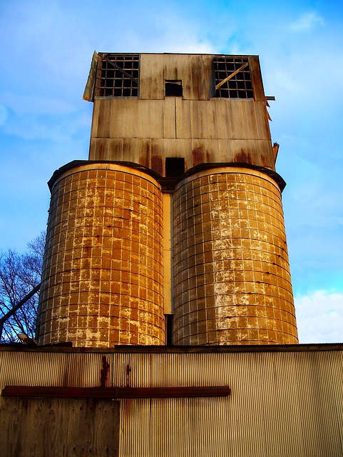
Leslie County courthouse in Hyden
| |
|
Location within the U.S. state of Kentucky
| |
|
مسقط Kentucky ضمن الولايات المتحدة | |
| الإحداثيات: Coordinates: | |
| البلد | |
| State |
|
| تأسست | 1878 |
| السَمِيْ | پرستون لسلي |
| Seat | Hyden |
| Largest city | Hyden |
| المساحة | |
| • الإجمالية | 404 ميل² (1٬050 كم²) |
| • البر | 401 ميل² (1٬040 كم²) |
| • الماء | 3٫6 ميل² (9 كم²) 0.9%% |
| التعداد | |
| • تقدير (2018) | 10٬143 |
| • الكثافة | 28/sq mi (11/km2) |
| منطقة التوقيت | Eastern (التوقيت العالمي المنسق−5) |
| • الصيفي | EDT (UTC−4) |
| Congressional district | 5th |
| المسقط الإلكتروني | lesliecounty.ky.gov |
مقاطعة لسلي بالإنگليزية: Leslie County هي إحدى المقاطعات في ولاية كنتكي في الولايات المتحدة. وحسب تعداد 2010، فإن عدد سكان المقاطعة كان 11,310 نسمة. عاصمة المقاطعة هي هايدن، كنتكي. لزلي هي مقاطعة جافة أي محظور بيع الكحول فيها.
تاريخ
مقاطعة لسلي تأسست في 1878. وقد أخذت اسمها من پرستون لسلي، حاكم كنتكي (1871-1875).
The Hurricane Creek mine disaster in a Leslie County coal mine in 1970 killed 38 people.
After resigning the presidency, Richard Nixon made his first public appearance at the Leslie County dedication of a recreation facility named for him. County Judge-Executive C. Allen Muncy claimed the Nixon invitation prompted the U.S. Department of Justice to obtain indictments of him and his associates on vote-fraud charges; while on appeal for his conviction, he won renomination in the Republican primary but lost the 1981 general election to independent Kermit Keen.
الجغرافيا
المقاطعات المجاورة
- Perry County (شمال شرق)
- Harlan County (جنوب شرق)
- Bell County (جنوب غرب)
- Clay County (غرب)
الديمغرافيا
| التعداد التاريخي | |||
|---|---|---|---|
| التعداد | Pop. | %± | |
| 1880 | 3٬740 | — | |
| 1890 | 3٬964 | 6�0% | |
| 1900 | 6٬753 | 70٫4% | |
| 1910 | 8٬976 | 32٫9% | |
| 1920 | 10٬097 | 12٫5% | |
| 1930 | 10٬765 | 6٫6% | |
| 1940 | 14٬981 | 39٫2% | |
| 1950 | 15٬537 | 3٫7% | |
| 1960 | 10٬941 | −29٫6% | |
| 1970 | 11٬623 | 6٫2% | |
| 1980 | 14٬882 | 28�0% | |
| 1990 | 13٬642 | −8٫3% | |
| 2000 | 12٬401 | −9٫1% | |
| 2010 | 11٬310 | −8٫8% | |
| تقدير 2018 | 10٬143 | −10٫3% | |
| U.S. Decennial Census 1790-1960 1900-1990 1990-2000 2010-2013 | |||
الاقتصاد
شركات الفحم في مقاطعة لزلي
- James River Coal Company
Communities
- Asher
- Bear Branch
- Big Rock
- Causey
- Chappell
- Cinda
- Confluence
- Cutshin
- Essie
- Frew
- Grassy
- Hare
- Hell for Certain
- Helton
- Hoskinston
- Hyden (county seat)
- Kaliopi
- Middlefork
- Mozelle
- Roark
- Sizerock
- Smilax
- Stinnett
- Thousandsticks
- Toulouse
- Warbranch
- Wendover
- Wooton
- Yeaddis
| Year | Republican | Democratic | Third parties |
|---|---|---|---|
| 2016 | 89.4% 4,015 | 8.9% 400 | 1.7% 77 |
| 2012 | 89.6% 4,439 | 8.7% 433 | 1.6% 81 |
| 2008 | 81.3% 3,574 | 17.4% 766 | 1.3% 57 |
| 2004 | 73.8% 3,661 | 25.5% 1,266 | 0.8% 37 |
| 2000 | 71.2% 3,159 | 27.3% 1,210 | 1.5% 65 |
| 1996 | 56.1% 2,296 | 35.8% 1,466 | 8.0% 328 |
| 1992 | 58.3% 2,879 | 32.2% 1,591 | 9.4% 466 |
| 1988 | 74.4% 3,280 | 25.1% 1,105 | 0.5% 24 |
| 1984 | 75.6% 3,385 | 24.0% 1,075 | 0.3% 15 |
| 1980 | 71.9% 3,536 | 27.0% 1,327 | 1.2% 58 |
| 1976 | 71.5% 3,770 | 28.0% 1,478 | 0.4% 23 |
| 1972 | 77.9% 3,299 | 21.6% 913 | 0.6% 24 |
| 1968 | 71.1% 2,615 | 22.5% 828 | 6.4% 236 |
| 1964 | 52.2% 1,971 | 47.6% 1,795 | 0.2% 8 |
| 1960 | 83.1% 3,894 | 17.0% 795 | |
| 1956 | 87.4% 3,770 | 12.3% 531 | 0.3% 14 |
| 1952 | 81.8% 3,239 | 17.8% 705 | 0.4% 15 |
| 1948 | 73.9% 2,397 | 24.2% 783 | 1.9% 62 |
| 1944 | 84.3% 2,679 | 15.7% 499 | 0.0% 0 |
| 1940 | 84.0% 3,292 | 16.0% 626 | 0.1% 3 |
| 1936 | 81.4% 2,716 | 18.5% 618 | 0.1% 3 |
| 1932 | 83.0% 2,810 | 16.8% 569 | 0.2% 8 |
| 1928 | 94.5% 2,806 | 5.4% 159 | 0.2% 6 |
| 1924 | 88.9% 2,052 | 9.7% 223 | 1.4% 33 |
| 1920 | 94.2% 2,576 | 5.2% 142 | 0.6% 16 |
| 1916 | 91.6% 1,516 | 8.0% 133 | 0.4% 6 |
| 1912 | 53.0% 606 | 9.2% 105 | 37.8% 433 |
See also
- Dry counties
- National Register of Historic Places listings in Leslie County, Kentucky
References
- ^ "State & County QuickFacts". United States Census Bureau. Archived from the original on June 7, 2011. Retrieved March 6, 2014.
- ^ "Find a County". National Association of Counties. Archived from the original on May 31, 2011. Retrieved 2011-06-07.
- ^ . Kentucky State Historical Society. 1903. p. 36.
- ^ http://www.kyenc.org/entry/l/LESLI02.html
- ^ "The Big Lever," Appalshop Inc., 1982
- ^ "Population and Housing Unit Estimates". Retrieved July 29, 2019.
- ^ "U.S. Decennial Census". United States Census Bureau. Archived from the original on April 26, 2015. Retrieved August 17, 2014.
- ^ "Historical Census Browser". University of Virginia Library. Retrieved August 17, 2014.
- ^ "Population of Counties by Decennial Census: 1900 to 1990". United States Census Bureau. Retrieved August 17, 2014.
- ^ "Census 2000 PHC-T-4. Ranking Tables for Counties: 1990 and 2000" (PDF). United States Census Bureau. Retrieved August 17, 2014.
- ^ James River Coal Company – Blue Diamond complex
- ^ James River Coal Company – Bledsoe complex
- ^ Leip, David. "Dave Leip's Atlas of U.S. Presidential Elections". uselectionatlas.org. Retrieved 2018-07-03.
Notes
وصلات خارجية
- The Kentucky Highlands Project
- LeslieCounty.Net - oldest and largest site dealing with Leslie County
نطقب:Leslie County, Kentucky نطقب:Eastern Mountain Coal Fields (Kentucky)