قناة سان كوِنتان
| Canal de Saint-Quentin | |
|---|---|
|
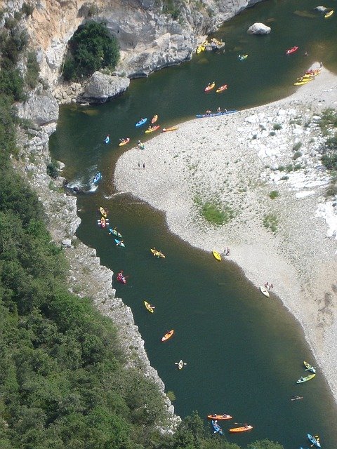
هويس نوييه-سور-إسكوعلى قناة سان-كوِنتان
| |
| المواصفات | |
| الطول | 92.5 كم |
| أقصى طول سفينة | 38.50 متر |
| أقصى عرض للسفينة | 5.05 متر |
| أقل غاطس سفن | 2.20 متر |
| أقل خلوص جوي للسفن | 3.50 متر |
| الأهوسة | 35 |
| الارتفاع الإجمالي | 43 m |
| الوضع | مفتوحة |
| التاريخ | |
| الأسماء السابقة | قناة كروزا أوقناة پيكاردي بين شوني وسان-سيمون، في 1738 |
| المالك الحالي | Voies Navigables de France |
| المهندس الرئيسي | المهندس الأصلي: Devicq في 1727. توفي في 1742. |
| مهندسون آخرون | عدّل المسار Laurent de Lyonne. العمل بدأ في 1768. |
| الجغرافيا | |
| نقطة البداية | Canalised Escaut River (Scheldt) in Cambrai |
| نقطة النهاية | شوني |
| إحداثيات البداية | |
| إحداثيات النهاية | |
| ترتبط مع | Canal latéral à l'Oise, Canal de l'Oise à l'Aisne, Canal de la Sambre à l'Oise, Canalised Escaut River |
قناة سان كوِنتان Canal de Saint-Quentin هي قناة في شمال فرنسا تربط نهر إسكوالمار في قنوات في كامبراي بـ Canal latéral à l'Oise وCanal de l'Oise à l'Aisne في شوني.
تاريخ
بُنيت القناة على مرحلتين، الثانية كانت أطول كثيرا من الأولى. وزيرا الملك كولبير ومازاران كلاهما اقترح ربط River Oise وSomme في القرن السابع عشر ونتج عن ذلك قناة كروزا أوقناة پيكاردي, بين شوني وسان-سيمون في 1738. البقية، التي تربط حوض السين بنهر إسكوكانت عملية طويلة. المصمم الأصلي، Devicq in 1727, died in 1742. Little was accomplished until Napoléon demanded that work begin again in 1801. He officiated at the opening in April 1810.
The canal was such a success that the locks had to be duplicated throughout in the early 20th century, at the same time deepening the channel, enlarging the tunnels, and increasing water supplies. Later improvements included electric barge traction on rails, installed during World War I, mechanising locks, and providing public lighting on the busiest sections. Later, the locks were equipped for automatic operation, using remote sensors, and more recently by handheld remote control. By 1878, up to 110 barges were crossing the summit level daily. The Canal du Nord was built as a duplicate route and completed in 1965. The canal carried more freight than any other man-made waterway in France in 1964.
معركة قناة سان كوِنتان
The Canal in World War I formed part of the Hindenburg Line, a German defensive position built during the winter of 1916–1917. The Allied crossing of the St Quentin Canal in 1918 was a significant part of the Hundred Days Offensive that led to the Armistice.
الملاحة
This canal is an asset for tourism, boating and on the towpath, especially the northern section in the Escaut valley, the spectacular summit level with its tunnels and the boat harbour in the basin at Saint-Quentin. Commercial traffic declined after opening of the Canal du Nord, and it is now consistently quiet and peaceful, although a few Freycinet barges still use this route.
على طولها
- PK 0 Cambrai
- PK 11 Masnières
- PK 18 Les Rues-des-Vignes
- PK 23 Honnecourt-sur-Escaut
- PK 28.5-35 Riqueval tunnel (5670m) Bony
- PK 42-43 Tronquoy tunnel (1098m) Lesdins
- PK 53 Saint-Quentin
- PK 62 Séraucourt-le-Grand
- PK 68 Right Petite Somme: St-Simon to Ham, closed 2006 (link to Canal de la Somme), route continues left
- PK 80.5 Voyaux
- PK 83 Tergnier
- PK 85 T-junction left 3.8 km branch to Canal de la Sambre à l'Oise Right continues as Canal de Saint-Quentin
- PK 92 Chauny, the canal continues as Canal latéral à l'Oise towards Paris. Left Canal de l'Oise à l'Aisne
المراجع
- ^ McKnight, Hugh (2005). . Sheridan House. pp. 16, 37–42. ISBN .
- ^ Edwards-May, David (2010). Inland Waterways of France. St Ives, Cambs., UK: Imray. ISBN .
وصلات خارجية
- Video showing the "Souterrain de Riqueval" and local area
- Canal de Saint-Quentin with maps and details of places, moorings and services (by the author of Inland Waterways of France, Imray)
- Navigation details for 80 French rivers and canals (French waterways website section)
| مشاع الفهم فيه ميديا متعلقة بموضوع Canal de Saint-Quentin. |